IMAGES TAKEN NEAR TO
Oatland Road, DIDCOT, OX11 8QF
Introduction
This page details the photographs taken nearby to Oatland Road, OX11 8QF by members of the Geograph project.
The Geograph project started in 2005 with the aim of publishing, organising and preserving representative images for every square kilometre of Great Britain, Ireland and the Isle of Man.

There are currently over 7.5m images from over14,400 individuals and you can help contribute to the project by visiting https://www.geograph.org.uk
Image Map (Loading...)


Getting Data...Please wait
Leaflet Map data © OpenStreetMap
Images are licensed for reuse under creativecommons.org/licenses/by-sa/2.0
Notes
- Clicking on the map will re-center to the selected point.
- The higher the marker number, the further away the image location is from the centre of the postcode.
Image Listing (35 Images Found)
Images are licensed for reuse under creativecommons.org/licenses/by-sa/2.0
Image
Details
Distance
1
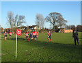
Rugby in Edmunds Park
Didcot vs Grove
Image: © Des Blenkinsopp
Taken: 8 Jan 2011
0.09 miles
2
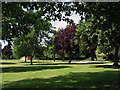
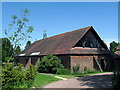
Edmunds Park
Didcot's Edmunds Park is largely lawn and sports pitches, but there is a pleasant wooded corner at the Newlands Avenue end.
Image: © Des Blenkinsopp
Taken: 22 Jun 2010
0.09 miles
3
Samor Way
This street was built on the site of an old canning factory.
There will still be folks in Didcot who remember Samor Baked Beans.
Image: © Des Blenkinsopp
Taken: 6 Apr 2011
0.09 miles
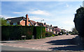
4
Houses on Newlands Avenue
Viewed from Edmunds Park.
Image: © Des Blenkinsopp
Taken: 22 Jun 2010
0.12 miles
5
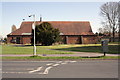
St Peter's Church
View across Newlands Avenue at the junction with Oatland Road. The grey Royal Mail cabinet replaced a letter box with an Ordnance Survey cut mark benchmark, see http://www.bench-marks.org.uk/bm22878
Image: © Roger Templeman
Taken: 26 Mar 2012
0.13 miles
7

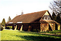
St Peters Church Roof
This weather vane is very apt given Didcot's fame as a railway town.
Image: © Des Blenkinsopp
Taken: 22 Jun 2010
0.14 miles
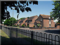
10
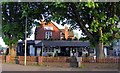
#28 Newlands Avenue
The Ordnance Survey verified a cut mark benchmark ( http://www.bench-marks.org.uk/bm22879 ) on the right end of the wall in front of the house in 1973, but the wall and drive to #30 appear to have been rebuilt in recent years.
Image: © Roger Templeman
Taken: 28 Mar 2012
0.17 miles