IMAGES TAKEN NEAR TO
Higher Hartshead, ASHTON-UNDER-LYNE, OL6 9AF
Introduction
This page details the photographs taken nearby to Higher Hartshead, OL6 9AF by members of the Geograph project.
The Geograph project started in 2005 with the aim of publishing, organising and preserving representative images for every square kilometre of Great Britain, Ireland and the Isle of Man.

There are currently over 7.5m images from over14,400 individuals and you can help contribute to the project by visiting https://www.geograph.org.uk
Image Map
Images are licensed for reuse under creativecommons.org/licenses/by-sa/2.0
Notes
- Clicking on the map will re-center to the selected point.
- The higher the marker number, the further away the image location is from the centre of the postcode.
Image Listing (44 Images Found)
Images are licensed for reuse under creativecommons.org/licenses/by-sa/2.0
Image
Details
Distance
1
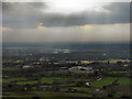
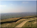
View Towards Ashton From Hartshead Pike
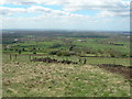
It is said (http://www.tameside.gov.uk/countryside/access/hartshead ) that on a clear day, four counties can be seen from Hartshead Pike, as well as landmarks such as Jodrell Bank, the Welsh hills and the Holme Moss transmitter mast. Although this was not such a clear day, looking towards Ashton, Lily Lanes and the new St Damian's Roman Catholic Science College building are clearly visible.
Image: © David Dixon
Taken: 13 Oct 2011
0.12 miles
2
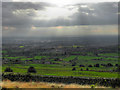
View From Hartshead Pike
It is said (http://www.tameside.gov.uk/countryside/access/hartshead ) that on a clear day, four counties can be seen from Hartshead Pike, as well as landmarks such as Jodrell Bank, the Welsh hills and the Holme Moss transmitter mast. This was not such a clear day. Looking towards Ashton and Manchester.
Image: © David Dixon
Taken: 13 Oct 2011
0.13 miles
3
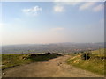
Oldham from Hartshead
A view towards Oldham from Hartshead in Tameside, Greater Manchester.
Image: © Steven Haslington
Taken: 8 Mar 2011
0.13 miles
5
Hartshead Pike to Manchester
Looking south west.
Image: © John Topping
Taken: 29 Apr 2006
0.14 miles
6
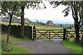
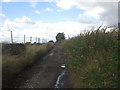
Near Hartshead Green
This area is on the western slopes leading up to Hartshead Pike.
Image: © Michael Fox
Taken: 28 Jul 2011
0.14 miles
7
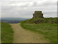
Hartshead Pike Well
Often marked as a well on maps is this the site of the original tower on the summit of the hill?
Image: © Kevin Waterhouse
Taken: 6 Oct 2017
0.15 miles
8
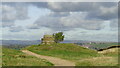
Hartshead Pike
Although the name "Hartshead Pike" is widely associated with the monument, it was originally the name of the hill itself. Although not the highest point on the hill, the Pike’s prominent position, 940 feet above sea level, has meant that, from early times, it has been the site of a beacon or signalling station. It is highly probable that the druids worshipped at Hartshead Pike during the Iron Age, and sacrifices may have been held to appease their gods.
The earliest structure on this spot may have been a stone pillar, erected to commemorate the passing through the area of King Canute, who is also remembered in the names of Knott Hill and Knott Lanes.
A tower had been built on the hill by the eighteenth century and was re-built in 1751 by a public subscription (Image]). However, it was badly damaged by lightning and a hundred years later, all that remained was this ring of stone standing just to the north of the present tower (Image]).
http://www.ashton-under-lyne.com/history/hartshead.htm -Ashton Under Lyne.com
http://en.wikipedia.org/wiki/Hartshead_Pike - Wikipedia
http://www.tameside.gov.uk/countryside/access/hartshead -Tameside MBC
Image: © David Dixon
Taken: 13 Oct 2011
0.15 miles
9
Oldham from Hartshead Pike
Oldham from Hartshead Pike, in Greater Manchester.
Image: © Steven Haslington
Taken: 8 Mar 2011
0.15 miles
10
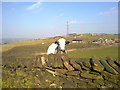
Cow at Hartshead
A curious cow in a farm at Hartshead, Greater Manchester.
Image: © Steven Haslington
Taken: 8 Mar 2011
0.15 miles