IMAGES TAKEN NEAR TO
Rochdale Road, ROCHDALE, OL16 4DU
Introduction
This page details the photographs taken nearby to Rochdale Road, OL16 4DU by members of the Geograph project.
The Geograph project started in 2005 with the aim of publishing, organising and preserving representative images for every square kilometre of Great Britain, Ireland and the Isle of Man.

There are currently over 7.5m images from over14,400 individuals and you can help contribute to the project by visiting https://www.geograph.org.uk
Image Map
Images are licensed for reuse under creativecommons.org/licenses/by-sa/2.0
Notes
- Clicking on the map will re-center to the selected point.
- The higher the marker number, the further away the image location is from the centre of the postcode.
Image Listing (38 Images Found)
Images are licensed for reuse under creativecommons.org/licenses/by-sa/2.0
Image
Details
Distance
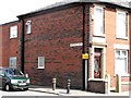
1
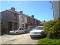
Whitehead Street, Milnrow
Whitehead Street in Milnrow, Greater Manchester, England.
Image: © Steven Haslington
Taken: 3 Jun 2011
0.05 miles
2
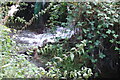
Inflow to the Beal river
This water runs into the Beal continually via a pipe. There is no stream visible on a 1:2500 O.S. So is it from a nearby spring that has been built over?
Image: © Bryan Tenny
Taken: 29 Sep 2020
0.13 miles
3
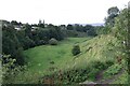
The Beal Valley
Viewed from Ashes Lane, the Beal Valley contains the River Beal, a tributary of the Roch, which is itself a tributary of the River Irwell.
Image: © Bryan Tenny
Taken: 29 Sep 2020
0.13 miles
4
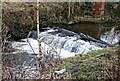
River Beal Weir
The weir on the river Beal in Milnrow from which Weir Rd in the 1970s housing estate on the site of Ashes farm takes its name.
Image: © Bryan Tenny
Taken: 17 Jan 2011
0.14 miles
6
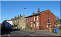
Uncouth
The corner of Uncouth Street and Rochdale Road, Milnrow, Lancashire.
Image: © Peter Thwaite
Taken: 2 Aug 2009
0.15 miles
8
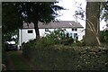
Ashes Farm
Situated on Ashes Lane this was an active farm until the mid 1970s when its fields were sold off for building. Its grounds contain the grave of John Stock after whom the nearby Stock Grove on the farm's former fields was built.
Image: © Bryan Tenny
Taken: 29 Sep 2020
0.16 miles
9
A patch of coltsfoot flowers
Coltsfoot (tussilago farfara) is a member of the daisy family. An extract of it is used in the hard rock candy, coltsfoot rock, it has been used in traditional medicine for coughs amongst other things. Its common name is because its leaves are said to resemble a colts foot, whilst its scientific name comes from 'tussis' Latin for a cough.
Image: © Bryan Tenny
Taken: 27 Mar 2020
0.16 miles
10
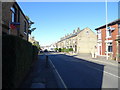
Rochdale Road, Firgrove
Looking north west on the A640.
Image: © JThomas
Taken: 18 Oct 2018
0.17 miles