IMAGES TAKEN NEAR TO
Eleanor Crescent, LONDON, NW7 1AH
Introduction
This page details the photographs taken nearby to Eleanor Crescent, NW7 1AH by members of the Geograph project.
The Geograph project started in 2005 with the aim of publishing, organising and preserving representative images for every square kilometre of Great Britain, Ireland and the Isle of Man.

There are currently over 7.5m images from over14,400 individuals and you can help contribute to the project by visiting https://www.geograph.org.uk
Image Map
Images are licensed for reuse under creativecommons.org/licenses/by-sa/2.0
Notes
- Clicking on the map will re-center to the selected point.
- The higher the marker number, the further away the image location is from the centre of the postcode.
Image Listing (44 Images Found)
Images are licensed for reuse under creativecommons.org/licenses/by-sa/2.0
Image
Details
Distance
3
Street Furniture
On the corner of Hillview Road and Burtonhole Lane in Mill Hill Village.
Image: © Martin Addison
Taken: 11 Mar 2012
0.07 miles
5
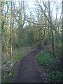
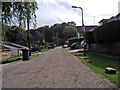
Footpath from Eleanor Crescent, Mill Hill
Image: © David Howard
Taken: 20 Feb 2013
0.09 miles
6
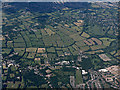
Mill Hill from the air
Totteridge and Chipping Barnet can be seen in the distance.
Image: © Thomas Nugent
Taken: 22 Jun 2015
0.10 miles
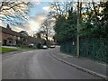
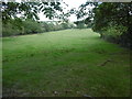
7
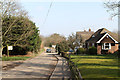
Burtonhole Lane
The sign on the left indicates the entrance to Burtonhole Farm. The lane declines into an un-metalled track beyond the distant trees and eventually becomes a road used as a public path.
Image: © Martin Addison
Taken: 11 Mar 2012
0.10 miles
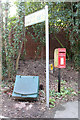
8

Entrance to Burtonhole Farm
Although the maps all show the name as Burtonhole Farm, the old sign beside the entrance reads Burton Hole farm and has the road outside as Burton Hole Lane. The words must have merged since the sign was made - which, with an 01 telephone number, must predate 1990 and is almost certainly older than that. The sign advertises the Pleasant Herd and indicates that the herd is made up of Blonde D'Aquitaine cattle. Details of the breed can be found on the British Blonde Society website at http://www.britishblondesociety.co.uk/ . Sadly, I didn't see any of the cattle on my way past.
Image: © Martin Addison
Taken: 11 Mar 2012
0.10 miles
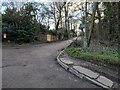
9
Burtonhole Farm
Seen from the lane adjacent to Finchley Nurseries. The farmhouse nestles amidst the trees whilst the barns are visible beyond.
Image: © Martin Addison
Taken: 11 Mar 2012
0.12 miles
10
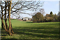
View from Burtonhole Lane near Burtonhole Farm
Burtonhole Lane is known as Gypsy Lane at its eastern end where it comes out to the southern end of Totteridge Green. It is a quiet country lane and was an old green lane, which now serves as a public bridleway and footpath. The hedgerows have been allowed to grow tall and bushy.
This view is at the western end of Burtonhole Lane next to Burtonhole Farm and close to Mill Hill. It looks down into the valley of the Folly Brook. There is quite a lot of traffic here as Finchley Nurseries and Mill Hill Country Club are to the left of this field.
Image: © Marathon
Taken: 5 Oct 2016
0.13 miles