IMAGES TAKEN NEAR TO
Brent Cross Gardens, LONDON, NW4 3BG
Introduction
This page details the photographs taken nearby to Brent Cross Gardens, NW4 3BG by members of the Geograph project.
The Geograph project started in 2005 with the aim of publishing, organising and preserving representative images for every square kilometre of Great Britain, Ireland and the Isle of Man.

There are currently over 7.5m images from over14,400 individuals and you can help contribute to the project by visiting https://www.geograph.org.uk
Image Map
Images are licensed for reuse under creativecommons.org/licenses/by-sa/2.0
Notes
- Clicking on the map will re-center to the selected point.
- The higher the marker number, the further away the image location is from the centre of the postcode.
Image Listing (243 Images Found)
Images are licensed for reuse under creativecommons.org/licenses/by-sa/2.0
Image
Details
Distance
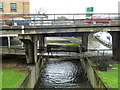
2
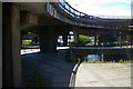
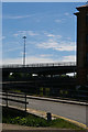
River Brent at Brent Cross
At the highest level the A41 passes over, at ground level, the North Circular Road, with the middle level between these occupied by the roads that allow connection between the two major arteries. The Brent passes below all of this.
Image: © Christopher Hilton
Taken: 22 May 2017
0.01 miles
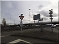
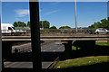
3
Ramp to subway
The first stage of crossing the Brent Cross interchange with bicycles.
Image: © David Lally
Taken: 6 Oct 2019
0.02 miles
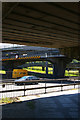
4
Under the A41
A young lady walks on the footbridge that is suspended beneath the central reservation of the A41 flyover. Behind, a van negotiates the roundabout at this junction between the A41 and the A406. Beneath, the traffic streams past on the North Circular Road. On the right a stunted Hawthorn bush grows.
Image: © Martin Addison
Taken: 26 Jul 2008
0.02 miles
5
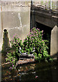
Temporary Island
A dead supermarket trolley lies on the bed of the River Brent. The small amount of silt it has collected is enough for ace coloniser, Broad-Leaved Willowherb, to thrive. The trolley had disappeared by 14th December 2008, presumably removed by the council or washed downstream after heavy rain.
Image: © Martin Addison
Taken: 26 Jul 2008
0.02 miles
6
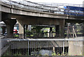
Under the flyover, Brent Cross
Taken from the footbridge suspended below the flyover at Brent Cross, this image shows the North Circular Road at the bottom level and, level with the camera, part of the roundabout that allows traffic to pass between the two main roads.
Image: © Christopher Hilton
Taken: 22 May 2017
0.02 miles
7
River Brent at Brent Cross
Looking upstream under the A41/A406 interchange.
Image: © Robin Webster
Taken: 26 Feb 2011
0.02 miles
8
Brent Cross junction
In the distance at the highest level the A41 passes over; at ground level, the North Circular Road; with the middle level between these occupied by the roads that allow connection between the two major arteries.
Image: © Christopher Hilton
Taken: 22 May 2017
0.02 miles
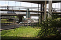
9
Brent Cross flyover, from the north
Behind the office buildings that creep in at the right of the picture, a tangle of roads at different levels marks the Brent Cross junction of the A41 and the North Circular Road.
Image: © Christopher Hilton
Taken: 22 May 2017
0.02 miles
10
Beneath Several Layers of Tarmac
The River Brent continues beneath the junction of the A406 and A41. This photo is taken from the pedestrian area on the southwest side of Cooper Road. In the foreground is a disused concrete bridge that used to give access to the North Circular from what is currently Brent Cross Gardens. It probably dates back to the 1930's. Immediately above is a sliproad from the A41 giving access to the North Circular and to Brent Cross via Cooper Road. There is also a roundabout at this level, the opposite side of which can be seen through the arches on the left of the photo, where the North Circular itself is visible. Above and behind the white and blue truck on the sliproad is the bridge carrying through traffic on the A41.
Image: © Martin Addison
Taken: 26 Jul 2008
0.03 miles