IMAGES TAKEN NEAR TO
Adelaide Road, LONDON, NW3 3PP
Introduction
This page details the photographs taken nearby to Adelaide Road, NW3 3PP by members of the Geograph project.
The Geograph project started in 2005 with the aim of publishing, organising and preserving representative images for every square kilometre of Great Britain, Ireland and the Isle of Man.

There are currently over 7.5m images from over14,400 individuals and you can help contribute to the project by visiting https://www.geograph.org.uk
Image Map
Images are licensed for reuse under creativecommons.org/licenses/by-sa/2.0
Notes
- Clicking on the map will re-center to the selected point.
- The higher the marker number, the further away the image location is from the centre of the postcode.
Image Listing (211 Images Found)
Images are licensed for reuse under creativecommons.org/licenses/by-sa/2.0
Image
Details
Distance
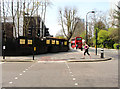
1
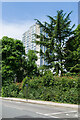
Dorney
One of a number of similar 23 storey tower blocks in the Chalcots Estate on Adelaide Road, built in 1967 as part of a mixed public/private estate designed by Dennis Lennon & Partners, developing an area that had previously been earmarked for an inner ring road (Ringway 1 - North Cross Route).
Image: © Ian Capper
Taken: 4 Jun 2022
0.02 miles
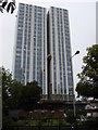
2
Fellows Road Pavement
A photo of the pavement on Fellows Road, with the tower block Bray on the left of the photo.
Image: © 192199
Taken: 5 Apr 2020
0.03 miles
3
Dorney Tower
Dorney Estate, Camden. The workmen have almost finished re-cladding this towerblock. Taken from Adelaide Road.
Image: © Oxyman
Taken: 21 Aug 2007
0.05 miles
4
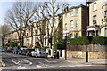
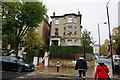
Fellows Road, London NW3
Looking west along Fellows Road from the junction with Primrose Hill Road. These large detached villas were built around 1865.
Image: © Kate Jewell
Taken: 30 Mar 2014
0.05 miles
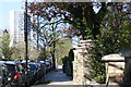
7
Fellows Road / Merton Rise, NW3
Shows the location of Image
Image: © Mike Quinn
Taken: 24 Jun 2008
0.08 miles
8
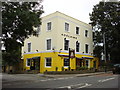
The Adelaide, on Adelaide Road
Pub, with yellow front.
Image: © Peter Barr
Taken: 6 Nov 2013
0.08 miles
9
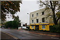
Adelaide Road, London NW3
Looking west from the junction with Primrose Hill Road. The 1970s housing to the left is undergoing a major refurbishment.
The large blocks of flats were designed by Dennis Lennon & Partners in consultation with S. A. G. Cook and built in the late 1960s and early 1970s as part of the post war development of this badly bomb damaged area. The nearest to the camera is Dorney, in the centre is Bray and the one in the far distance is Burnham. Out of sight, round the bend in the road is Taplow. Because the free holder of the historical Chalcots Estate in this area was Eton College all four blocks were named after villages near Eton.
Image: © Kate Jewell
Taken: 30 Mar 2014
0.08 miles
10
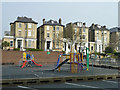
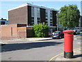
Play area and Fellows Road houses
The play area is primarily for the high density housing estate this side of the road.
Image: © Robin Webster
Taken: 27 Mar 2011
0.09 miles