IMAGES TAKEN NEAR TO
Grampian Gardens, LONDON, NW2 1JG
Introduction
This page details the photographs taken nearby to Grampian Gardens, NW2 1JG by members of the Geograph project.
The Geograph project started in 2005 with the aim of publishing, organising and preserving representative images for every square kilometre of Great Britain, Ireland and the Isle of Man.

There are currently over 7.5m images from over14,400 individuals and you can help contribute to the project by visiting https://www.geograph.org.uk
Image Map
Images are licensed for reuse under creativecommons.org/licenses/by-sa/2.0
Notes
- Clicking on the map will re-center to the selected point.
- The higher the marker number, the further away the image location is from the centre of the postcode.
Image Listing (33 Images Found)
Images are licensed for reuse under creativecommons.org/licenses/by-sa/2.0
Image
Details
Distance
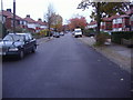
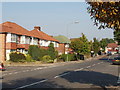
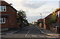
2
Pennine Drive
Pennine Drive, as befits its name, forms the backbone of this 1930's housing estate around which concentric side roads form an oval pattern. The side roads are all named after ranges of hills and areas adjoining the Pennines. This is the junction with Cleveland Gardens on the left and Cumbrian Gardens on the right.
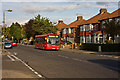
First DML44087 on the 226 route catches the evening sun as it waits for a 102 going in the other direction.
Image: © Martin Addison
Taken: 10 Oct 2009
0.11 miles
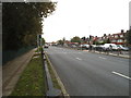
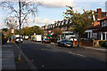
3
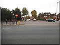
Hendon Way at the junction of Pennine Drive
Image: © David Howard
Taken: 24 Oct 2014
0.13 miles
4
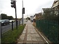
The pavement on Hendon Way, Cricklewood
Image: © David Howard
Taken: 24 Oct 2014
0.13 miles
5
Pennine Drive, Cricklewood
This housing estate is noticeable on the map as the layout has two concentric ellipses and a central spine, which is Pennine Drive. Other streets also have hilly names - Cheviot, Cumbrian, Cotswold, Chiltern, Cleveland, Quantock and Grampian Gardens, Purbeck Drive.
Image: © David Hawgood
Taken: 15 Oct 2005
0.13 miles
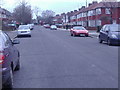
8
Cleveland Gardens
Looking northeast from the junction with Purbeck Drive. Mainly 1930's semidetached housing though there look to have been a few later additions, possibly filling in bomb damage from WWII.
Image: © Martin Addison
Taken: 10 Oct 2009
0.14 miles
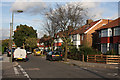
9
Purbeck Drive
This road serves as a link road between Pennine Drive at its central point and the concentic side roads that make up the estate. This view is taken from the junction with Cleveland Gardens. The next junction is with Cotswold Gardens. Beyond the fence are Clitterhouse Fields, playing fields on what used to be Clitterhouse Farm. The tower block in the distance is one of three on the Whitefield Estate.
Image: © Martin Addison
Taken: 10 Oct 2009
0.15 miles
10
Pennine Drive
Shops with housing above in the centre of the 1930's housing estate. Pennine Drive, as befits its name, forms the backbone of the estate around which concentric side roads form an oval pattern. The side roads are all named after ranges of hills.
Image: © Martin Addison
Taken: 10 Oct 2009
0.15 miles