IMAGES TAKEN NEAR TO
Woodville Road, LONDON, NW11 9TP
Introduction
This page details the photographs taken nearby to Woodville Road, NW11 9TP by members of the Geograph project.
The Geograph project started in 2005 with the aim of publishing, organising and preserving representative images for every square kilometre of Great Britain, Ireland and the Isle of Man.

There are currently over 7.5m images from over14,400 individuals and you can help contribute to the project by visiting https://www.geograph.org.uk
Image Map (Loading...)


Getting Data...Please wait
Leaflet Map data © OpenStreetMap
Images are licensed for reuse under creativecommons.org/licenses/by-sa/2.0
Notes
- Clicking on the map will re-center to the selected point.
- The higher the marker number, the further away the image location is from the centre of the postcode.
Image Listing (221 Images Found)
Images are licensed for reuse under creativecommons.org/licenses/by-sa/2.0
Image
Details
Distance
1
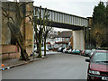
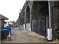
Railway bridge over Woodville Road
The skew crossing for the Northern Line needs quite a lengthy span.
Image: © Robin Webster
Taken: 26 Feb 2011
0.02 miles
2
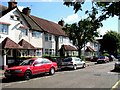
St Marys Rd
St Mary’s Rd Brent Cross. These houses are typical of those built during the 1920 & 30’s as London’s suburbs grew.
Image: © Glyn Baker
Taken: 17 Sep 2005
0.03 miles
3
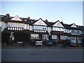
Houses on Woodville Road, Golders Green
Image: © David Howard
Taken: 24 Sep 2014
0.03 miles
4
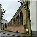
Railway arches between Woodville Road and Elmcroft Crescent
They carry the Northern Line.
Image: © Robin Webster
Taken: 26 Feb 2011
0.03 miles
6
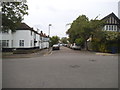
St Marys Road at the junction of Woodville Road
Image: © David Howard
Taken: 27 May 2015
0.04 miles
7
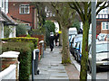
Walking on Shabbat, St Mary's Road, NW11
Going to or from a synagogue in rain garb. There are many synagogues and several orthodox ones in this area.
Image: © Robin Webster
Taken: 26 Feb 2011
0.04 miles
8
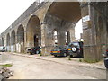
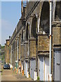
Golders Green: Northern Line railway viaduct
The extension of the underground railway to Edgware in the 1920s involved the construction of a major viaduct to take the tracks over the valley of the River Brent. The viaduct starts here in Elmcroft Crescent and, apart from the embanked section around Image runs for about 700 metres to Shirehall Lane and Martin's Image
It is evident from old Ordnance Survey maps that the railway cut a swathe through the existing housing estates, and that then fairly new residences in Elmscroft Crescent, Montpelier Rise and Woodstock Avenue must have been demolished to make way for it.
Image: © Nigel Cox
Taken: 14 Feb 2010
0.04 miles
9
Underground viaduct
Carries the Northern Line (Edgware Branch) over the valley south of Brent Cross station.
Image: © Mike Quinn
Taken: 3 Aug 2011
0.04 miles
10
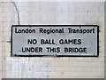
No ball games under bridge NT13
Where the Northern line crosses Woodville Road. It is unlikely that crack was caused by ball games.
Image: © Robin Webster
Taken: 26 Feb 2011
0.04 miles