IMAGES TAKEN NEAR TO
Highfield Road, LONDON, NW11 9LT
Introduction
This page details the photographs taken nearby to Highfield Road, NW11 9LT by members of the Geograph project.
The Geograph project started in 2005 with the aim of publishing, organising and preserving representative images for every square kilometre of Great Britain, Ireland and the Isle of Man.

There are currently over 7.5m images from over14,400 individuals and you can help contribute to the project by visiting https://www.geograph.org.uk
Image Map (Loading...)


Getting Data...Please wait
Leaflet Map data © OpenStreetMap
Images are licensed for reuse under creativecommons.org/licenses/by-sa/2.0
Notes
- Clicking on the map will re-center to the selected point.
- The higher the marker number, the further away the image location is from the centre of the postcode.
Image Listing (139 Images Found)
Images are licensed for reuse under creativecommons.org/licenses/by-sa/2.0
Image
Details
Distance
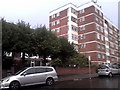
1
Princes Park Avenue, Golders Green
Mr Prince was one of the original developers of the area when the stations were built allowing commuters to move to the new houses being built. The Prince Albert pub site on the left was originally supposed to have a block of flats built on the vacant lot after it was demolished around ten years ago, but the plan since failed and is now wasted space.
Image: © David Howard
Taken: 3 Oct 2012
0.03 miles
2
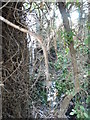
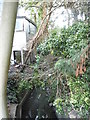
Brook by Highfield Road, Golders Green
Although I've walked around the area all my life this was the first time I saw the brook here, one of the only locations where it is visible on a public road. It runs from the River Brent at Brent Bridge and stops just short of Ravenscroft Avenue, and explains why only one road connects Golders Green with Temple Fortune between the North Circular and Ravenscroft Avenue as it runs at the back of people's gardens.
Image: © David Howard
Taken: 3 Oct 2012
0.03 miles
4
Brook by Highfield Road, Golders Green
Although I've walked around the area all my life this was the first time I saw the brook here, one of the only locations where it is visible on a public road. It runs from the River Brent at Brent Bridge and stops just short of Ravenscroft Avenue, and explains why only one road connects Golders Green with Temple Fortune between the North Circular and Ravenscroft Avenue as it runs at the back of people's gardens.
Image: © David Howard
Taken: 3 Oct 2012
0.04 miles
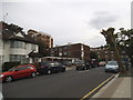
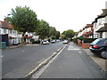
6
Highfield Road at Junction with Golders Green Road, London NW11
Image: © Robin Sones
Taken: 14 Apr 2007
0.05 miles
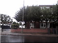
7
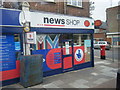
Prince's Parade Post Office
Corner of Heather Gardens NW11
Image: © Colin Pyle
Taken: 20 Oct 2009
0.05 miles
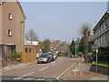
9
Golders Green Road in the rain
Princes Park Road is on the left
Image: © David Howard
Taken: 14 Aug 2015
0.06 miles