IMAGES TAKEN NEAR TO
Brookland Close, LONDON, NW11 6DJ
Introduction
This page details the photographs taken nearby to Brookland Close, NW11 6DJ by members of the Geograph project.
The Geograph project started in 2005 with the aim of publishing, organising and preserving representative images for every square kilometre of Great Britain, Ireland and the Isle of Man.

There are currently over 7.5m images from over14,400 individuals and you can help contribute to the project by visiting https://www.geograph.org.uk
Image Map
Images are licensed for reuse under creativecommons.org/licenses/by-sa/2.0
Notes
- Clicking on the map will re-center to the selected point.
- The higher the marker number, the further away the image location is from the centre of the postcode.
Image Listing (135 Images Found)
Images are licensed for reuse under creativecommons.org/licenses/by-sa/2.0
Image
Details
Distance
1
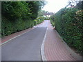
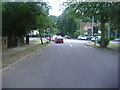
Brookland Close, Hampstead Garden Suburb
Image: © David Howard
Taken: 17 Jul 2013
0.02 miles
2
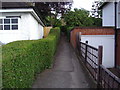
Path from Brookland Hill to Hutchings Walk
Image: © David Howard
Taken: 30 Jun 2006
0.05 miles
3
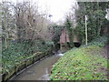
Mutton Brook in Hampstead Garden Suburb
Mutton Brook eventually merges with Dollis Brook to form the River Brent. It is seen here looking upstream towards the A1 Falloden Way bridge. The sign is a London Borough of Barnet one stating "Polluted Water - Keep Out". The cause of the pollution is not stated, but since this is downstream of a main road speculatively there may be, or may have been at some time in the past, some oil-based pollution that the usual surface water drain arrangements are, or were, not intercepting correctly.
The co-ordinates of the subject and photographer positions are taken from the Ordnance Survey 1:10,000 scale mapping because the 1:50,000 scale mapping is cartographically badly distorted by the need to represent the A1 much wider than it actually is.
Image: © Nigel Cox
Taken: 20 Feb 2011
0.05 miles
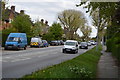
5
Brookland Rise looking towards Falloden Way
Image: © David Howard
Taken: 17 Jul 2013
0.05 miles
6
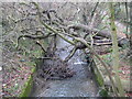
Mutton Brook in Hampstead Garden Suburb
Mutton Brook eventually merges with Dollis Brook to form the River Brent. It is seen here looking downstream from the Brookland Rise bridge, where a large tree has fallen across it and has the potential to create a flood situation. If debris brought downstream from elsewhere in a heavy flow event accumulates against the branches in the brook it could eventually block the brook and force the water to flow out of bank.
The co-ordinates of the subject and photographer positions are taken from the Ordnance Survey 1:10,000 scale mapping because the 1:50,000 scale mapping is cartographically badly distorted by the need to represent the nearby A1 much wider than it actually is.
Image: © Nigel Cox
Taken: 20 Feb 2011
0.06 miles
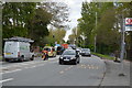
9
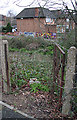
Gate on Falloden Way
A gate in the fence presumably to allow council workmen in to trim the vegetation along Mutton Brook, which is hidden in the dip beyond. A footpath runs alongside the graffiti painted wall, linking Gloucester Drive with Brooklands Rise. The houses are on Connaught Drive.
Image: © Martin Addison
Taken: 24 Mar 2008
0.06 miles
10
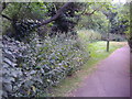
Path along Mutton Brook, Temple Fortune
Image: © David Howard
Taken: 17 Jul 2013
0.07 miles