
IMAGES TAKEN NEAR TO
Paulet Way, LONDON, NW10 9DL
Introduction
This page details the photographs taken nearby to Paulet Way, NW10 9DL by members of the Geograph project.
The Geograph project started in 2005 with the aim of publishing, organising and preserving representative images for every square kilometre of Great Britain, Ireland and the Isle of Man.

There are currently over 7.5m images from over14,400 individuals and you can help contribute to the project by visiting https://www.geograph.org.uk
Image Map
Images are licensed for reuse under creativecommons.org/licenses/by-sa/2.0
Notes
- Clicking on the map will re-center to the selected point.
- The higher the marker number, the further away the image location is from the centre of the postcode.
Image Listing (94 Images Found)
Images are licensed for reuse under creativecommons.org/licenses/by-sa/2.0
Image
Details
Distance
1
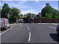
Bridge Road bridge
The goods line goes over Bridge Road where it becomes Taylors Lane.
Image: © David Howard
Taken: 24 Jun 2009
0.06 miles
2
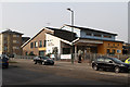
Church End & Roundwood Unity Centre
Located on the corner of Church Road and Creukhorne Road, the centre was built circa 2007. The Unity Centre provides recreational, educational and cultural activities in a secure and welcoming environment - to quote from a brochure produced by Fortunegate who currently manage the site and housing on the adjacent estates.
Image: © Martin Addison
Taken: 1 Mar 2012
0.06 miles
3
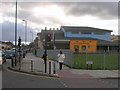
Church Road NW10 junction with Hawkins Road NW10
Image: © Robin Sones
Taken: 27 Mar 2009
0.06 miles
4
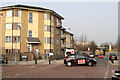
Taylors Lane
There have been some changes in road names since the area was redeveloped in the early 1970's. Taylors Lane used to connect with Church Road but now the section where I am standing is called Hawkins Road and only the section diving under the bridge retains its original name. On the left Creukhorne Road whilst on the right is Tynsdale Road. The distant bridge carries the Midland railway line between Acton Wells Junction and Cricklewood. The RED driving instructor is executing an circular turn in the junction to avoid doing a three point turn.
Image: © Martin Addison
Taken: 1 Mar 2012
0.08 miles
5
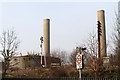
Railway Beside Taylors Lane Power Station
A Semaphore signal and disused telegraph pole stand beside the tracks of the Midland Railway's Acton Wells to Cricklewood line. Behind are the chimneys and oil tanks of Taylors Lane Power Station. The current power station which opened in 1979 on the site of a previous one, is powered by gas-oil. There are sidings beside the tanks for rail deliveries but these are no longer connected to the rail network so presumably delivery of oil is now carried out by road.
Image: © Martin Addison
Taken: 1 Mar 2012
0.08 miles
6
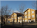
Flats on Church Road, NW10
The west side, south of Mayo Road.
Image: © Mike Quinn
Taken: 15 Feb 2012
0.10 miles
7
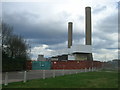
Taylor's Lane Power Station, Leicester Road, NW11
Image: © Robin Sones
Taken: 27 Mar 2009
0.10 miles
8
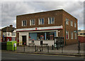
Church End Post Office, London NW10 (1953)
Image: © Jim Osley
Taken: 4 Feb 2013
0.10 miles
9
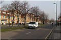
Church Road
This straight dual carriageway section of the A407 seems slightly incongruous in an area of shopping parades and terraced housing. The road was widened in the early 1970's as part of a redevelopment of the area to the west of the road with low-rise maisonette style housing.
Image: © Martin Addison
Taken: 1 Mar 2012
0.10 miles
10
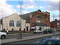
Restoration Revival Fellowship Apostolic Church, Church Road NW10
At the junction of West Ella Road, NW10 (southern junction).
Image: © Robin Sones
Taken: 27 Mar 2009
0.10 miles