IMAGES TAKEN NEAR TO
Lindford Drive, NORWICH, NR4 6LT
Introduction
This page details the photographs taken nearby to Lindford Drive, NR4 6LT by members of the Geograph project.
The Geograph project started in 2005 with the aim of publishing, organising and preserving representative images for every square kilometre of Great Britain, Ireland and the Isle of Man.

There are currently over 7.5m images from over14,400 individuals and you can help contribute to the project by visiting https://www.geograph.org.uk
Image Map
Images are licensed for reuse under creativecommons.org/licenses/by-sa/2.0
Notes
- Clicking on the map will re-center to the selected point.
- The higher the marker number, the further away the image location is from the centre of the postcode.
Image Listing (26 Images Found)
Images are licensed for reuse under creativecommons.org/licenses/by-sa/2.0
Image
Details
Distance
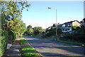
1
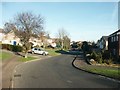
Housing, Eaton
These detached houses on Lindford Drive are a little newer, smaller and less individual than those on Marston Lane.
Image: © Katy Walters
Taken: 12 Nov 2005
0.03 miles
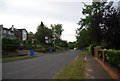
2
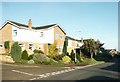
Housing, Eaton
Church Lane and Marston Lane are characterised by mainly 1970s / 1980s detached houses in individual designs. Closer to the village centre, the houses are older.
Image: © Katy Walters
Taken: 12 Nov 2005
0.08 miles
6
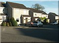
Housing, Eaton
At the furthest point from the village are the smaller, cheaper houses - 1980s terraces and link-detached residences.
Image: © Katy Walters
Taken: 12 Nov 2005
0.18 miles
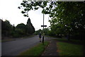
8
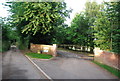
Scout Activity Centre entrance, Church Lane, Eaton
Image: © N Chadwick
Taken: 1 Jul 2010
0.19 miles
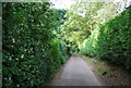
9
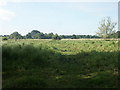
Marston Marshes
Looking SW from the entrance near the golf club, off Marston Lane.
Image: © Katy Walters
Taken: 16 Jul 2005
0.20 miles
10
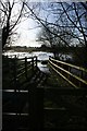
Marston Marshes in flood
Looking along one of the access gates, next to a pen used when loading or unloading the cattle that graze these marshes.
Image: © Katy Walters
Taken: 21 Jan 2007
0.20 miles