IMAGES TAKEN NEAR TO
Thorpland, FAKENHAM, NR21 0HA
Introduction
This page details the photographs taken nearby to Thorpland, NR21 0HA by members of the Geograph project.
The Geograph project started in 2005 with the aim of publishing, organising and preserving representative images for every square kilometre of Great Britain, Ireland and the Isle of Man.

There are currently over 7.5m images from over14,400 individuals and you can help contribute to the project by visiting https://www.geograph.org.uk
Image Map
Images are licensed for reuse under creativecommons.org/licenses/by-sa/2.0
Notes
- Clicking on the map will re-center to the selected point.
- The higher the marker number, the further away the image location is from the centre of the postcode.
Image Listing (26 Images Found)
Images are licensed for reuse under creativecommons.org/licenses/by-sa/2.0
Image
Details
Distance
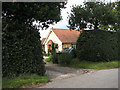
1
A pair of red-brick cottages
Of the three properties along this section of Great Snoring Road these cottages are located between the house on the corner > http://www.geograph.org.uk/photo/988921 and a pair of smaller cottages adjoining in the south > http://www.geograph.org.uk/photo/988946. A date stone indicates that they were built in 1911. See also > http://www.geograph.org.uk/photo/988928.
Image: © Evelyn Simak
Taken: 1 Oct 2008
0.01 miles
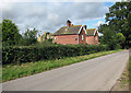
2
Thorpland Cottages
View south along Great Snoring Road which connects with the A148 > http://www.geograph.org.uk/photo/988885 a short distance further south. Here it passes Thorpland Cottages.
Image: © Evelyn Simak
Taken: 1 Oct 2008
0.02 miles
3
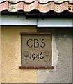
Date stone on a pair of cottages
Bearing the initials 'CBS' and the date '1946' - the latter flanked by one of England's national emblems, the Tudor Rose, and by the Scottish national emblem, the thistle. See also > http://www.geograph.org.uk/photo/988949 and http://www.geograph.org.uk/photo/988946.
Image: © Evelyn Simak
Taken: 1 Oct 2008
0.02 miles
4
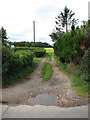
A short access road
This short track separates the centre pair of cottages > http://www.geograph.org.uk/photo/988932 from the property adjoining in the south > http://www.geograph.org.uk/photo/988946.
Image: © Evelyn Simak
Taken: 1 Oct 2008
0.02 miles
5
A glimpse through the hedge
The southernmost cottages located along this section of Great Snoring Road are obscured from view by a high hedge. They are adjoining a pair of red-brick cottages > http://www.geograph.org.uk/photo/988932. A date stone indicates that they were built in 1946 > http://www.geograph.org.uk/photo/988959. See also > http://www.geograph.org.uk/photo/988949.
Image: © Evelyn Simak
Taken: 1 Oct 2008
0.02 miles
6
Cottages on Great Snoring Road
Of the three properties along this section of Great Snoring Road these cottages are located between the house on the corner > http://www.geograph.org.uk/photo/988921 and a pair of smaller cottages adjoining in the south > http://www.geograph.org.uk/photo/988946. A date stone indicates that they were built in 1911. See also > http://www.geograph.org.uk/photo/988932.
Image: © Evelyn Simak
Taken: 1 Oct 2008
0.02 miles
7
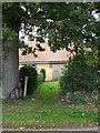
Entrance into a garden
The southernmost cottages located along this section of Great Snoring Road are obscured from view by a high hedge. They are adjoining a pair of red-brick cottages > http://www.geograph.org.uk/photo/988932. A date stone indicates that they were built in 1946 > http://www.geograph.org.uk/photo/988959. See also > http://www.geograph.org.uk/photo/988946.
Image: © Evelyn Simak
Taken: 1 Oct 2008
0.02 miles
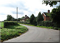
8
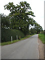
Great Snoring Road
Great Snoring Road turns off the A148 > http://www.geograph.org.uk/photo/988885 and leads to the village of Great Snoring, further to the northeast. Here it runs past Thorpland Cottages which are obscured from view by the hedge seen at left.
Image: © Evelyn Simak
Taken: 1 Oct 2008
0.04 miles
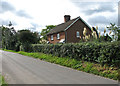
9
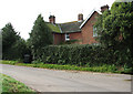
House on the corner
This red-brick house - see also > http://www.geograph.org.uk/photo/988921 - is located by a sharp bend of Great Snoring Road, beside the turnoff of the access road to Thorpland Lodge Farm > http://www.geograph.org.uk/photo/988963.
Image: © Evelyn Simak
Taken: 1 Oct 2008
0.04 miles
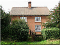
10
Red-brick house
This is the largest of the properties called Thorpland Cottages; it is located by a sharp bend in Great Snoring Road beside the entrance of the access to Thorpland Lodge Farm > http://www.geograph.org.uk/photo/988963. See also > http://www.geograph.org.uk/photo/988915.
Image: © Evelyn Simak
Taken: 1 Oct 2008
0.04 miles