IMAGES TAKEN NEAR TO
Breeze Avenue, NORWICH, NR11 6WF
Introduction
This page details the photographs taken nearby to Breeze Avenue, NR11 6WF by members of the Geograph project.
The Geograph project started in 2005 with the aim of publishing, organising and preserving representative images for every square kilometre of Great Britain, Ireland and the Isle of Man.

There are currently over 7.5m images from over14,400 individuals and you can help contribute to the project by visiting https://www.geograph.org.uk
Image Map
Images are licensed for reuse under creativecommons.org/licenses/by-sa/2.0
Notes
- Clicking on the map will re-center to the selected point.
- The higher the marker number, the further away the image location is from the centre of the postcode.
Image Listing (34 Images Found)
Images are licensed for reuse under creativecommons.org/licenses/by-sa/2.0
Image
Details
Distance
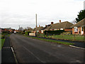
1
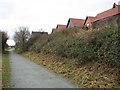
Houses in Mileham Drive
These properties back onto the dismantled railway trackbed which now forms a section of the Marriott's Way.
Image: © Evelyn Simak
Taken: 4 Mar 2009
0.06 miles
2
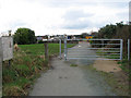
Gate on the Marriott's Way
Approaching Mileham Drive on the Marriott's Way this gate and a sign affixed to it alerts walkers to traffic ahead.
Image: © Evelyn Simak
Taken: 4 Mar 2009
0.06 miles
3
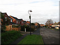
New housing, old lamppost
On Yaxleys Lane
Image: © Evelyn Simak
Taken: 28 Nov 2007
0.07 miles
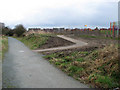
4
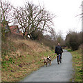
Exercising the dogs
This section of the Marriott's Way, linking Norwich Road with Hungate Street, is well frequented by dog owners exercising their pets.
Image: © Evelyn Simak
Taken: 4 Mar 2009
0.09 miles
6
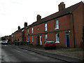
Clifford and Farleigh Terraces
At the end of Yaxleys Lane near the junction with Cawston Road, these terraces were built in 1903 and 1904, respectively.
Image: © Evelyn Simak
Taken: 28 Nov 2007
0.13 miles
7
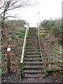
Steps to Hungate Street
Steps leading from the dismantled railway trackbed, now forming a section of the Marriott's Way, to Hungate Street.
Image: © Evelyn Simak
Taken: 4 Mar 2009
0.14 miles
8
View east along the Marriott's Way
This section of the Marriott's way links Norwich Road, further to the east, with Hungate Street, and with Mileham Drive beyond.
Image: © Evelyn Simak
Taken: 4 Mar 2009
0.14 miles
9
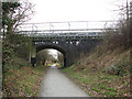
Bridge over the Marriott's Way
The bridge carries Hungate Street over the dismantled railway trackbed which now forms a section of the Marriott's Way. A footbridge runs parallel with the roadbridge. See also > http://www.geograph.org.uk/photo/622378.
Image: © Evelyn Simak
Taken: 4 Mar 2009
0.16 miles
10
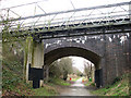
Road bridge and footbridge
The bridge carries Hungate Street over the dismantled railway trackbed which now forms a section of the Marriott's Way. A footbridge runs parallel with the roadbridge. See also > http://www.geograph.org.uk/photo/622378. This section of the Marriott's Way links Norwich Road with Hungate Street and leads to the village of Cawston, further to the west.
Image: © Evelyn Simak
Taken: 4 Mar 2009
0.16 miles