IMAGES TAKEN NEAR TO
The Moorings, PONTYPOOL, NP4 5NB
Introduction
This page details the photographs taken nearby to The Moorings, NP4 5NB by members of the Geograph project.
The Geograph project started in 2005 with the aim of publishing, organising and preserving representative images for every square kilometre of Great Britain, Ireland and the Isle of Man.

There are currently over 7.5m images from over14,400 individuals and you can help contribute to the project by visiting https://www.geograph.org.uk
Image Map
Images are licensed for reuse under creativecommons.org/licenses/by-sa/2.0
Notes
- Clicking on the map will re-center to the selected point.
- The higher the marker number, the further away the image location is from the centre of the postcode.
Image Listing (138 Images Found)
Images are licensed for reuse under creativecommons.org/licenses/by-sa/2.0
Image
Details
Distance
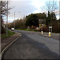
1
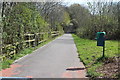
NCR 492 from Stafford Road
Cycle lane down from roundabout at junction of Stafford Road and Maesderwen Road.
Image: © M J Roscoe
Taken: 12 Apr 2019
0.04 miles
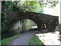
2
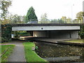
Bridge 51A, Monmouthshire & Brecon Canal
The bridge carries the A472 over the canal.
Image: © Jaggery
Taken: 21 Oct 2009
0.04 miles
3
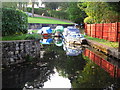
Pontymoel Boatyard
Boats in the little boatyard at Pontymoel have some colourful coverings to protect them from the weather.
Image: © David Roberts
Taken: 18 Oct 2009
0.05 miles
4
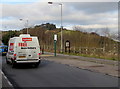
Iceland home delivery van, Stafford Road, Pontypool
Viewed in late January 2015 when Iceland shoppers (in-store or via the Iceland website)
can have free home delivery if they spend at least £25.
Image: © Jaggery
Taken: 27 Jan 2015
0.06 miles
5
This way for Upper Race and Cwmynyscoy
Near a roundabout at the Stafford Road and Maesderwen Road junction
near Griffithstown, a sign points left towards Upper Race and Cwmynyscoy.
Image: © Jaggery
Taken: 27 Jan 2015
0.06 miles
6
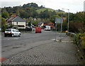
Maesderwen Road, Pontymoel
The view from Stafford Road.
Image: © Jaggery
Taken: 21 Oct 2009
0.06 miles
7
Bridge 51
Bridge over the Mon & Brecon canal
Image: © Colin Madge
Taken: 31 Mar 2008
0.06 miles
8
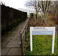
Path from Stafford Road to Maesderwen Rise, Pontypool
Maesderwen Rise http://www.geograph.org.uk/photo/4325556 is managed by Bron Afon Community Housing Association.
Image: © Jaggery
Taken: 27 Jan 2015
0.07 miles
9
Long bus stop on the east side of Stafford Road, Pontypool
The area marked as a bus stop extends for 65 metres.
Image: © Jaggery
Taken: 27 Jan 2015
0.07 miles
10
Obscured view of allotments, Pontypool
This is the best (or least bad) view I got of a small area of allotments set below Stafford Road.
Image: © Jaggery
Taken: 27 Jan 2015
0.07 miles