IMAGES TAKEN NEAR TO
Belle Vue Lane, CWMBRAN, NP44 5AL
Introduction
This page details the photographs taken nearby to Belle Vue Lane, NP44 5AL by members of the Geograph project.
The Geograph project started in 2005 with the aim of publishing, organising and preserving representative images for every square kilometre of Great Britain, Ireland and the Isle of Man.

There are currently over 7.5m images from over14,400 individuals and you can help contribute to the project by visiting https://www.geograph.org.uk
Image Map
Images are licensed for reuse under creativecommons.org/licenses/by-sa/2.0
Notes
- Clicking on the map will re-center to the selected point.
- The higher the marker number, the further away the image location is from the centre of the postcode.
Image Listing (33 Images Found)
Images are licensed for reuse under creativecommons.org/licenses/by-sa/2.0
Image
Details
Distance
1
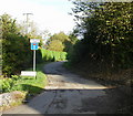
Belle Vue Lane, Upper Cwmbran
Such an insignificant lane, it seems, that neither the OS online maps, nor the local A-Z Street Atlas, bothers to name it.
Image: © Jaggery
Taken: 17 Oct 2009
0.09 miles
2

Kissing gate to a track on the SE side of The Square, Upper Cwmbran
The track heads towards Belle Vue Lane.
Image: © Jaggery
Taken: 7 Jan 2012
0.11 miles
3
Track on the south side of The Square, Upper Cwmbran
The track leads to a kissing gate and a field gate. http://www.geograph.org.uk/photo/3398639
Image: © Jaggery
Taken: 7 Jan 2012
0.12 miles
4
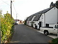
Graig View, Upper Cwmbran
Graig View is a group of interestingly-roofed houses on Tram Road.
Image: © Jaggery
Taken: 17 Oct 2009
0.13 miles
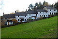
5
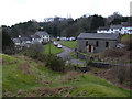
The Square, Upper Cwmbran
Built for the workers of the local coalmine in around 1820. The cottages originally occupied three sides of a square, but some have been demolished. Also shown is the local Methodist Chapel. The photo is taken from the overgrown spoil tip.
Image: © Chris Harris
Taken: 9 Mar 2003
0.14 miles
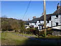
6
SE side of The Square, Upper Cwmbran
This is one of the oldest parts of Cwmbran, dating from c1840. It is also
the highest part of the town. This area is about 225 metres (c 740ft) above mean sea level.
Image: © Jaggery
Taken: 7 Jan 2012
0.14 miles
7
Terrace of houses in the Square, Upper Cwmbran
This is an area full of disused mines and quarries, explaining the presence of terraces such as this.
Image: © Ruth Sharville
Taken: 2 Apr 2013
0.14 miles
8
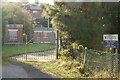
Entrance to Blaen Bran service reservoir, Upper Cwmbran
Image: © Jaggery
Taken: 17 Oct 2009
0.15 miles
9
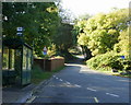
Bus terminus, Upper Cwmbran
The bus stop is the terminus of the route 8 service from Cwmbran bus station, operated by Terry Ward. The road ahead climbs towards The Square http://www.geograph.org.uk/photo/328454.
Image: © Jaggery
Taken: 17 Oct 2009
0.15 miles
10
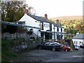
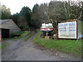
The Bush Inn, Upper Cwmbran
Little is known about the history of the Bush Inn. One possibility is that the pub originally consisted of two cottages which were linked to form the existing premises. The Bush Inn is shown on an 1860s OS map together with the now demolished Crown. There is an inn shown on an 1830s map, but it is unclear whether this was The Bush Inn or The Crown.
The Bush Inn , The Crown, The Squirrel (at the Square - now demolished) and The Queen http://www.geograph.org.uk/photo/1612705 were used by workers at the adjacent quarry, mine and brickyards, all now closed.
Image: © Jaggery
Taken: 17 Oct 2009
0.16 miles