IMAGES TAKEN NEAR TO
Croesyceiliog, CWMBRAN, NP44 2XJ
Introduction
This page details the photographs taken nearby to NP44 2XJ by members of the Geograph project.
The Geograph project started in 2005 with the aim of publishing, organising and preserving representative images for every square kilometre of Great Britain, Ireland and the Isle of Man.

There are currently over 7.5m images from over14,400 individuals and you can help contribute to the project by visiting https://www.geograph.org.uk
Image Map
Images are licensed for reuse under creativecommons.org/licenses/by-sa/2.0
Notes
- Clicking on the map will re-center to the selected point.
- The higher the marker number, the further away the image location is from the centre of the postcode.
Image Listing (103 Images Found)
Images are licensed for reuse under creativecommons.org/licenses/by-sa/2.0
Image
Details
Distance
1
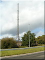
Communications mast, Croesyceiliog, Cwmbran
Viewed across Croesyceiliog Bypass (A4042). The mast is on the eastern side of the Gwent Police headquarters site. http://www.geograph.org.uk/photo/2599237
Image: © Jaggery
Taken: 13 Sep 2011
0.01 miles
2
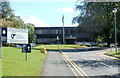
Gwent Police HQ, Croesyceiliog, Cwmbran
The area covered by Gwent Police is about 600 square miles, bounded by Abergavenny in the north, Newport in the south, Chepstow in the east and Caerphilly in the west.
Gwent was an ancient kingdom in SE Wales. From 1974 to 1996, it was the name of a county made up of most of the former administrative county of Monmouthshire and the county borough of Newport. Gwent lives on in some names, such as the police force and the rugby team Newport Gwent Dragons.
A local newspaper continues to use Gwent, as a shorthand way of referring to the area known as Monmouthshire before 1974.
Image: © Jaggery
Taken: 13 Sep 2011
0.05 miles
3
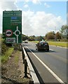
A4042 approaches Turnpike Roundabout, Cwmbran
The A4042, here named the Croesyceiliog Bypass, heads south towards a roundabout from which are roads to Caerleon via Llanfrechfa and Ponthir (the B4236), and Turnpike Road for Croesyceiliog and the rest of Cwmbran. Stay on the A4042 for Newport.
Image: © Jaggery
Taken: 13 Sep 2011
0.05 miles
4
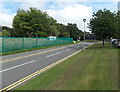
Road to Gwent Police Headquarters in Croesyceiliog, Cwmbran
The road passes green fencing at the perimeter of the demolition site http://www.geograph.org.uk/photo/3633069
in which once stood County Hall.
Image: © Jaggery
Taken: 30 Aug 2013
0.06 miles
5
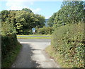
Lane east to farmland from Croesyceiliog Bypass
Viewed across the A4042. A narrow lane leads to three farms and a cottage.
Image: © Jaggery
Taken: 13 Sep 2011
0.06 miles
6
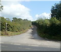
Lane reaches the Croesyceiliog Bypass
The lane connects three farms and a cottage with the A4042, which is a dual carriageway here. Only a left turn is allowed. Drivers wishing to travel in the opposite direction can do so at the Turnpike Roundabout, 300 metres away.
Image: © Jaggery
Taken: 13 Sep 2011
0.06 miles
7
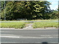
Footway across the central reservation, Croesyceiliog Bypass
Pedestrians reaching the A4042 from this lane http://www.geograph.org.uk/photo/2601080 can cross here.
Image: © Jaggery
Taken: 13 Sep 2011
0.06 miles
8
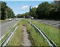
Footpath between the central reservation barriers, Croesyceiliog Bypass
The footpath between the barriers allows walkers to and from this lane http://www.geograph.org.uk/photo/2601080 to cross the busy A4042 to a kissing gate http://www.geograph.org.uk/photo/2601094 leading into the County Hall site.
Image: © Jaggery
Taken: 13 Sep 2011
0.06 miles
9
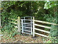
Kissing gate to County Hall, Croesyceiliog
On the west side of the A4042 (Croesyceiliog Bypass), opposite a pedestrian crossing, http://www.geograph.org.uk/photo/2601086 a gate leads to a path into the County Hall http://www.geograph.org.uk/photo/2599278 site.
Image: © Jaggery
Taken: 13 Sep 2011
0.06 miles
10
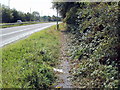
Track along the west side of the Croesyceiliog Bypass
For pedestrians who've crossed the A4042, http://www.geograph.org.uk/photo/2601086 the track is an alternative to this kissing gate http://www.geograph.org.uk/photo/2601094 leading into the grounds of County Hall. I chose the kissing gate, so don't know if the track reaches Turnpike Roundabout, 300 metres away.
Image: © Jaggery
Taken: 13 Sep 2011
0.06 miles