IMAGES TAKEN NEAR TO
Sluvad Road, PONTYPOOL, NP4 0SX
Introduction
This page details the photographs taken nearby to Sluvad Road, NP4 0SX by members of the Geograph project.
The Geograph project started in 2005 with the aim of publishing, organising and preserving representative images for every square kilometre of Great Britain, Ireland and the Isle of Man.

There are currently over 7.5m images from over14,400 individuals and you can help contribute to the project by visiting https://www.geograph.org.uk
Image Map
Images are licensed for reuse under creativecommons.org/licenses/by-sa/2.0
Notes
- Clicking on the map will re-center to the selected point.
- The higher the marker number, the further away the image location is from the centre of the postcode.
Image Listing (63 Images Found)
Images are licensed for reuse under creativecommons.org/licenses/by-sa/2.0
Image
Details
Distance
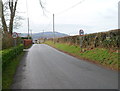
1
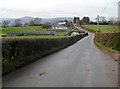
Looking west along Sluvad Road towards New Inn
Viewed from the edge of a farm entrance track. http://www.geograph.org.uk/photo/2796315
Image: © Jaggery
Taken: 6 Feb 2012
0.06 miles
2
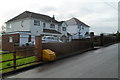
Sluvad Road houses east of New Inn
The houses are on the south side of Sluvad Road, about 400 metres east of Jerusalem Lane, New Inn.
Image: © Jaggery
Taken: 6 Feb 2012
0.08 miles
3
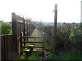
Footpath to St Mary's church, Panteg
A stile at the edge of Sluvad Road leads to a footpath heading south. St Mary's church http://www.geograph.org.uk/photo/1667480 is about 400 metres away.
Image: © Jaggery
Taken: 6 Feb 2012
0.08 miles
4
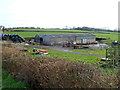
Farm buildings and black storage bags, Sluvad Road east of New Inn
Viewed across a hedge on the south side of Sluvad Road.
Image: © Jaggery
Taken: 6 Feb 2012
0.09 miles
5
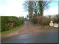
Farm entrance track, Sluvad Road east of New Inn
The track heads away from the north side of Sluvad Road. The name sign on the left shows LLWYN-Y-CELYN FARM. The name sign on the right shows CROES FACH FARM. Also on the right are notices stating that free range eggs are available, and also 25 kg of potatoes for £5.
Image: © Jaggery
Taken: 6 Feb 2012
0.13 miles
6
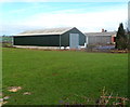
Groes-fach Farm buildings east of New Inn
Viewed from Sluvad Road, about 600 metres east of the Jerusalem Lane junction in New Inn.
Image: © Jaggery
Taken: 6 Feb 2012
0.13 miles
7
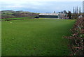
Field and farm buildings on the north side of Sluvad Road near New Inn
The buildings are about 600 metres east of Jerusalem Lane, New Inn.
Image: © Jaggery
Taken: 6 Feb 2012
0.13 miles
8
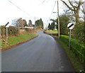
End of 30mph speed limit on Sluvad Road near New Inn
Beyond a group of houses http://www.geograph.org.uk/photo/1677181 at the western end of Sluvad Road, the speed limit increases from 30mph to the National Speed Limit.
Image: © Jaggery
Taken: 6 Feb 2012
0.13 miles
9

Track near the churchyard, Panteg
Near St Mary's churchyard Panteg viewed from this https://www.geograph.org.uk/photo/7270583 rusty gate in April 2022.
Image: © Jaggery
Taken: 3 Apr 2022
0.17 miles
10
30mph speed limit at the western end of Sluvad Road near New Inn
At the approach to a group of houses http://www.geograph.org.uk/photo/1677181 at the western end of Sluvad Road, the National Speed Limit reduces to a 30mph speed limit.
Image: © Jaggery
Taken: 6 Feb 2012
0.19 miles