IMAGES TAKEN NEAR TO
Rockfield Road, MONMOUTH, NP25 5AU

Introduction

This page details the photographs taken nearby to Rockfield Road, NP25 5AU by members of the Geograph project.

The Geograph project started in 2005 with the aim of publishing, organising and preserving representative images for every square kilometre of Great Britain, Ireland and the Isle of Man.

There are currently over 7.5m images from over14,400 individuals and you can help contribute to the project by visiting https://www.geograph.org.uk

Image Map


Images are licensed for reuse under creativecommons.org/licenses/by-sa/2.0
Notes
  • Clicking on the map will re-center to the selected point.
  • The higher the marker number, the further away the image location is from the centre of the postcode.

Image Listing (120 Images Found)

Images are licensed for reuse under creativecommons.org/licenses/by-sa/2.0
  • ...
Image
Details
Distance
1
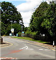
NW along Rockfield Road, Monmouth
The B4233 Rockfield Road northwest of the Watery Lane junction. The entrance to a Co-op is in the background.
Image: © Jaggery Taken: 18 Aug 2020
0.02 miles
2
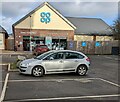
Co-op Monmouth
Set back from Rockfield Road in north Monmouth.
Image: © Jaggery Taken: 9 Jan 2022
0.02 miles
3
Three businesses set back from Rockfield Road, Monmouth
In view in January 2022 are Queens fish & chips shop, Ace Bicycles and Abbey Vets.
Image: © Jaggery Taken: 9 Jan 2022
0.02 miles
4
Rooftop solar panels, New Bungalows, Watery Lane, Monmouth
Viewed in August 2020. There were no solar panels here in a June 2011 Google Street View.
Image: © Jaggery Taken: 18 Aug 2020
0.04 miles
5
Rockfield Avenue
With severely pollarded trees on both sides of the avenue. King's Wood in the distance (195m).
Image: © Pauline E Taken: 7 Apr 2009
0.04 miles
6
Children's playground, Monmouth
Viewed from the Rockfield Road pavement.
Image: © Jaggery Taken: 18 Aug 2020
0.05 miles
7
Large bilingual nameboard facing Rockfield Road, Monmouth
In August 2020 the Monmouthshire County Council board shows "Overmonnow Primary School, Nursery Unit and Special Needs Resource Base" and its Welsh equivalent.
Image: © Jaggery Taken: 18 Aug 2020
0.05 miles
8
Watery Lane, Over Monnow
Part of Offa's Dyke Path, south of the Brook Estate.
Image: © Pauline E Taken: 7 Apr 2009
0.05 miles
9
Magnificent magnolia
At the junction of Rockfield Road and Rockfield Avenue.
Image: © Pauline E Taken: 7 Apr 2009
0.06 miles
10
Rockfield Road
The B4233 heading for Abergavenny. Housing to the left, poultry sheds and farmland to the right.
Image: © Pauline E Taken: 7 Apr 2009
0.06 miles
  • ...