IMAGES TAKEN NEAR TO
Ganarew, MONMOUTH, NP25 3SS
Introduction
This page details the photographs taken nearby to NP25 3SS by members of the Geograph project.
The Geograph project started in 2005 with the aim of publishing, organising and preserving representative images for every square kilometre of Great Britain, Ireland and the Isle of Man.

There are currently over 7.5m images from over14,400 individuals and you can help contribute to the project by visiting https://www.geograph.org.uk
Image Map
Images are licensed for reuse under creativecommons.org/licenses/by-sa/2.0
Notes
- Clicking on the map will re-center to the selected point.
- The higher the marker number, the further away the image location is from the centre of the postcode.
Image Listing (22 Images Found)
Images are licensed for reuse under creativecommons.org/licenses/by-sa/2.0
Image
Details
Distance
1

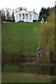
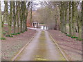
Sellarsbrooke
Grand house near the A4o at Ganarew, here viewed from the passing footpath. The house which is Grade II listed https://historicengland.org.uk/listing/the-list/list-entry/1224921?section=official-list-entry was built around 1800 with the Ionic portico added in 1970.
Image: © Philip Halling
Taken: 3 Oct 2023
0.02 miles
2
Sallersbrook, near Ganarew
Sallersbrook is an imposing Georgian House near Ganarew, it was built around 1800. Here it is viewed from the public footpath passing through its grounds.
Image: © Philip Halling
Taken: 14 Mar 2009
0.04 miles
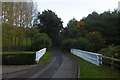
3
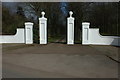
Entrance to Sallersbrook
Gated entrance to the country house, Sallersbrook.
Image: © Philip Halling
Taken: 14 Mar 2009
0.08 miles
4
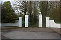
The entrance to Sellarsbrooke Park, Ganarew
Image: © David Howard
Taken: 23 Apr 2023
0.11 miles
5
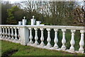
Balustrade at Sellarsbrooke Park, Ganarew
Image: © David Howard
Taken: 23 Apr 2023
0.11 miles
6
Folly?
This appears to be a small roman temple(?) situated in a small lake. If that's not a folly.....? It appeared to be in the grounds of a house with four large doric columns and little else. (I really need to do more research)
Image: © Stuart Wilding
Taken: 10 Mar 2006
0.11 miles
7
Yellow road, Ganarew
Fancy fencing where the road crosses a brook. There has been a lot of recent tree planting in the area. Names like Millennium Wood are a bit of a giveaway.
Image: © Richard Webb
Taken: 20 Oct 2016
0.11 miles
8
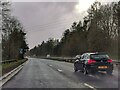
Ganarew : A40
Looking along the A40 dual carriageway.
Image: © Lewis Clarke
Taken: 22 Mar 2023
0.20 miles
9
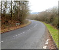
Slip road off the A40
At the Ganarew/Lewstone turn off the north-eastbound carriageway.
Image: © Jonathan Billinger
Taken: 13 Jul 2009
0.21 miles
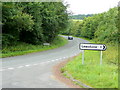
10
Eastern boundary of Ganarew
The boundary sign is on the side of a minor road about 80 metres west of the A40 junction.
Ganarew is a hamlet in southern Herefordshire, England, less than a mile from the River Wye and the border with Wales.
Image: © Jaggery
Taken: 12 Feb 2012
0.22 miles