IMAGES TAKEN NEAR TO
Hillcrest Close, MONMOUTH, NP25 3LN
Introduction
This page details the photographs taken nearby to Hillcrest Close, NP25 3LN by members of the Geograph project.
The Geograph project started in 2005 with the aim of publishing, organising and preserving representative images for every square kilometre of Great Britain, Ireland and the Isle of Man.

There are currently over 7.5m images from over14,400 individuals and you can help contribute to the project by visiting https://www.geograph.org.uk
Image Map
Images are licensed for reuse under creativecommons.org/licenses/by-sa/2.0
Notes
- Clicking on the map will re-center to the selected point.
- The higher the marker number, the further away the image location is from the centre of the postcode.
Image Listing (93 Images Found)
Images are licensed for reuse under creativecommons.org/licenses/by-sa/2.0
Image
Details
Distance
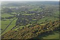
1
Justin's Hill and Wyesham from the Kymin
Image: © Roy Parkhouse
Taken: 15 Feb 2000
0.02 miles
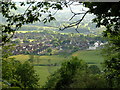
2
Wyesham
Wyesham in the foreground with Monmouth in the middle distance
Image: © Peter Randall-Cook
Taken: 31 Oct 2010
0.08 miles
3
Junction of Justin's Hill and Highmeadow, Wyesham
Viewed from Justin's Hill which continues on the left. Highmeadow is on the right.
Image: © Jaggery
Taken: 26 Apr 2015
0.08 miles
5
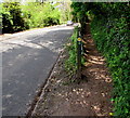
Offa's Dyke Path diverges from Staunton Road near Monmouth
The path is one of several walking routes up to the top of Kymin Hill, about 800 ft (c 240 metres) above sea level. The path here is less than 130 ft (c 40 metres) above sea level, so a steep ascent lies ahead.
Image: © Jaggery
Taken: 26 Apr 2015
0.09 miles
6
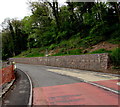
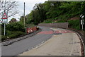
Staunton Road bank reinforcement near Monmouth
Viewed across the A4136 Staunton Road in late April 2015.
The stone wall, reinforced by wire meshing, is not in a June 2011 Google Earth Street View.
Image: © Jaggery
Taken: 26 Apr 2015
0.10 miles
7
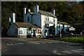
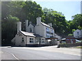
Mayhill Hotel, Monmouth
The Mayhill Hotel on the side of the A4136 at May Hill, Monmouth.
Image: © Philip Halling
Taken: 4 Nov 2007
0.10 miles
8
Hazardous driving conditions for three miles head along Staunton Road from Monmouth
The sign alongside the A4136 Staunton Road showing potentially slippery road surface doesn't tell all the story. The route ahead is winding and steep, with precipitous drops into the Wye valley. Driving needs much concentration at the best of times. This is not a route I would use in snowy or icy weather.
Image: © Jaggery
Taken: 26 Apr 2015
0.11 miles
9
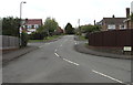
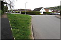
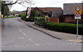
Hillcrest Road, Wyesham
From Wyesham Road. The name sign on the right shows that Hillcrest Road leads to several cul-de-sacs.
Image: © Jaggery
Taken: 26 Apr 2015
0.11 miles