IMAGES TAKEN NEAR TO
Peacehaven, TREDEGAR, NP22 4BZ
Introduction
This page details the photographs taken nearby to Peacehaven, NP22 4BZ by members of the Geograph project.
The Geograph project started in 2005 with the aim of publishing, organising and preserving representative images for every square kilometre of Great Britain, Ireland and the Isle of Man.

There are currently over 7.5m images from over14,400 individuals and you can help contribute to the project by visiting https://www.geograph.org.uk
Image Map
Images are licensed for reuse under creativecommons.org/licenses/by-sa/2.0
Notes
- Clicking on the map will re-center to the selected point.
- The higher the marker number, the further away the image location is from the centre of the postcode.
Image Listing (28 Images Found)
Images are licensed for reuse under creativecommons.org/licenses/by-sa/2.0
Image
Details
Distance
1
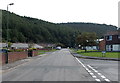
Towards Coed y Rhyd, Peacehaven, Tredegar
Looking towards the wooded high ground of Coed y Rhyd from Peacehaven,
an area of housing in the SE of Tredegar.
Image: © Jaggery
Taken: 5 Sep 2013
0.07 miles
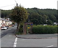
2
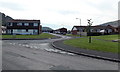
Right turn for Peacehaven Court, Tredegar
A view in Peacehaven, an area of housing in the SE of Tredegar.
Image: © Jaggery
Taken: 5 Sep 2013
0.07 miles
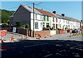
3
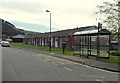
Row of bungalows and bus shelter in Peacehaven, Tredegar
Peacehaven is an area of housing in the SE of Tredegar.
Image: © Jaggery
Taken: 5 Sep 2013
0.13 miles
4
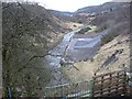
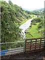
Sirhowy River looking downriver, Peacehaven
Image: © Robin Drayton
Taken: 18 Feb 2009
0.14 miles
5
Sirhowy River
Looking down from the river bridge on the road just off the A4048 roundabout which leads to Ponchin Crescent.
Image: © Sally Lloyd
Taken: 22 Jul 2007
0.14 miles
6
Brompton Place, Tredegar
Viewed across Pochin Crescent.
Image: © Jaggery
Taken: 6 Jul 2013
0.15 miles
7
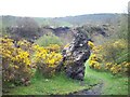
Iron slag and gorse
This is one of a pair of lumps of iron slag about3 metres high on the open ground south of Peacehaven and just off the new Sirhowy valley cycleway
Image: © nantcoly
Taken: 29 Apr 2008
0.16 miles
8
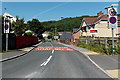
Southern edge of Tredegar
A view along Pochin Crescent in the Peacehaven area of Tredegar.
Heathfield Roundabout and the A4048 http://www.geograph.org.uk/photo/3542960 are behind the camera.
The National Speed Limit on this side of the signs reduces to 30mph ahead.
The red and blue circular signs showing End mark the end of a no stopping (clearway) zone.
Image: © Jaggery
Taken: 6 Jul 2013
0.17 miles
9
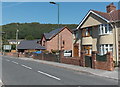
Houses at the southern edge of Tredegar
Viewed across Pochin Crescent near Heathfield Roundabout. http://www.geograph.org.uk/photo/3542960
The detached house centre left was built c2009.
Image: © Jaggery
Taken: 6 Jul 2013
0.18 miles
10
Entrance to Vale View Allotments, Tredegar
The allotments occupy a rectangular site, 100 metres by 50 metres. This is an upland location, about 280 metres (c920 feet) above sea level. At this height, killing frosts are likely to occur later in spring and earlier in autumn than in allotments near sea level in coastal South Wales.
Vale View houses http://www.geograph.org.uk/photo/3637788 are on the left.
Image: © Jaggery
Taken: 5 Sep 2013
0.18 miles