IMAGES TAKEN NEAR TO
Bedwellty Pits, TREDEGAR, NP22 4BW
Introduction
This page details the photographs taken nearby to Bedwellty Pits, NP22 4BW by members of the Geograph project.
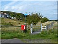
The Geograph project started in 2005 with the aim of publishing, organising and preserving representative images for every square kilometre of Great Britain, Ireland and the Isle of Man.

There are currently over 7.5m images from over14,400 individuals and you can help contribute to the project by visiting https://www.geograph.org.uk
Image Map
Images are licensed for reuse under creativecommons.org/licenses/by-sa/2.0
Notes
- Clicking on the map will re-center to the selected point.
- The higher the marker number, the further away the image location is from the centre of the postcode.
Image Listing (31 Images Found)
Images are licensed for reuse under creativecommons.org/licenses/by-sa/2.0
Image
Details
Distance
1
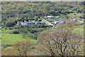
Bedwellty Pits
The village is principally two rows of terrsced houses. The shorter Railway Houses row is just to the left (out of shot) The central inclined road Image goes up and to the left to the A4048, partly hidden in trees. The row of vehicles below the left-hand houses are on the former railway trackbed.
Image: © M J Roscoe
Taken: 27 May 2021
0.01 miles
2
Former railway track, Bedwellty Pits
This was the site of Bedwellty Pits Halt on the route of the London & North Western Railway (LNWR) railway through the Sirhowy Valley.
It is due to be tarmacked and then will become part of National Cycle Route 467.
Image: © Robin Drayton
Taken: 27 Sep 2013
0.02 miles
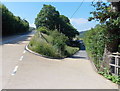
3
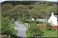
Road in village of Bedwellty Pits
Looking up toward the A4048 (hidden by trees) from the bottom of the road where it meets NCR 467 Image The mobile phone mast is next to the A4048. Mynydd Bedwellte is on the skyline.
Image: © M J Roscoe
Taken: 27 May 2021
0.02 miles
4
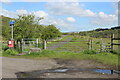
NCR 467 to Tredegar & Bryn Bach Park
Off-road resumption north, on a former railway track bed from Blackwood, of the cycle route which followed the highway from Hollybush to Bedwellty Pits. Since 2013 Image the fenced off area has been widened and a field gate and pedestrian gate installed at the start of the lane.
Image: © M J Roscoe
Taken: 27 May 2021
0.04 miles
5
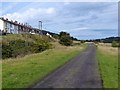
National Cycle Route, Bedwellty Pits
This is National Cycle Route 467 which follows the route northwards of the London & North Western Railway (LNWR) railway up to Tredegar.
Image: © Robin Drayton
Taken: 27 Sep 2013
0.06 miles
6
Side road to Bedwellty Pits and Railway Houses south of Tredegar
The road on the right descends from the A4048 towards an area of housing. There are two long rows of houses which together are named Bedwellty Pits. There is also a short named Railway Houses.
The activities after which the houses are names have both long since ceased. The area now has reverted to a rural appearance.
Image: © Jaggery
Taken: 6 Jul 2013
0.07 miles
7
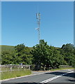
Arqiva telecoms mast, Bedwellty Pits
Viewed across the A4048. This is one of more than 1,000 Arqiva
radio and television transmission sites in the UK and Ireland.
Arqiva's main customers are broadcasters and mobile phone network operators.
Image: © Jaggery
Taken: 6 Jul 2013
0.08 miles
8
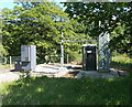
Equipment at the base of a telecoms mast near Bedwellty Pits
A glimpse inside a fenced-off Arqiva site at the edge of the A4048.
The base of this mast http://www.geograph.org.uk/photo/3546755 is on the right.
Image: © Jaggery
Taken: 6 Jul 2013
0.08 miles
9
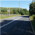
Slow at a bend in the A4048 near Bedwellty Pits
Looking towards an Arqiva telecoms mast. http://www.geograph.org.uk/photo/3546755
Image: © Jaggery
Taken: 6 Jul 2013
0.08 miles
10
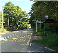
Bedwellty Pits bus shelters
Located alongside the A4048, on bus route 56 from Tredegar to Newport (left side) and Newport to Tredegar (right side). A sign points left towards houses in Bedwellty Pits, and National Cycle Network route 46.
Image: © Jaggery
Taken: 6 Jul 2013
0.08 miles