IMAGES TAKEN NEAR TO
New Road, TREDEGAR, NP22 4BL
Introduction
This page details the photographs taken nearby to New Road, NP22 4BL by members of the Geograph project.
The Geograph project started in 2005 with the aim of publishing, organising and preserving representative images for every square kilometre of Great Britain, Ireland and the Isle of Man.

There are currently over 7.5m images from over14,400 individuals and you can help contribute to the project by visiting https://www.geograph.org.uk
Image Map
Images are licensed for reuse under creativecommons.org/licenses/by-sa/2.0
Notes
- Clicking on the map will re-center to the selected point.
- The higher the marker number, the further away the image location is from the centre of the postcode.
Image Listing (12 Images Found)
Images are licensed for reuse under creativecommons.org/licenses/by-sa/2.0
Image
Details
Distance
1
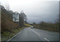
New Road houses south of Tredegar
Viewed across the A4048.
Image: © Jaggery
Taken: 6 Jul 2013
0.03 miles
2
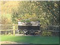
No more carrying coal
A reminder of the industrial past of this area.
Image: © Robin Drayton
Taken: 28 Nov 2007
0.03 miles
4
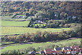
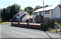
Upper Sirhowy Valley near Peacehaven
The houses in the foreground are at the southern end of Peacehaven. The River Sirhowy runs just in front in front of the line of trees. Just beyond NCR 467 runs parallel with the river. The houses at the foot of the far hill front onto the A4048.
Image: © M J Roscoe
Taken: 19 Oct 2018
0.09 miles
5
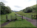
Llwybr i Byllau Bedwellte / Path to Bedwellty Pits
Llwybr troed a llwybr seiclo yn mynd i gyfeiriad Pyllau Bedwellte,
A footpath and cycle path heading towards Bedwellty Pits.
Image: © Alan Richards
Taken: 22 May 2022
0.09 miles
6
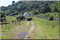
Track alongside A4048, New Road
A track which turns left down hill after the green container; the houses in the background are Coronation Villas.
Image: © M J Roscoe
Taken: 6 Jul 2017
0.12 miles
7
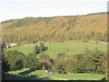
Sirhowy Valley near Tredegar
The River Sirhowy runs through the foreground trees. The main field beyond this is a landscaped coal tip. Note that contours are not shown for this field http://getamap.ordnancesurvey.co.uk/getamap/frames.htm?mapAction=gaz&gazName=g&gazString=SO155065 .
Image: © Robin Drayton
Taken: 4 Nov 2006
0.13 miles
8
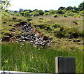
Rocky bed of a dried-up gully south of Tredegar
Viewed from the A4048. The gully has dried up in early July.
Image: © Jaggery
Taken: 6 Jul 2013
0.14 miles
9
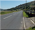
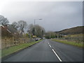
New Road south of Hunt's Lodge near Tredegar
The A4048 heads towards Hollybush and Markham.
Image: © Jaggery
Taken: 6 Jul 2013
0.20 miles