IMAGES TAKEN NEAR TO
Bryngaer Place, NEWPORT, NP20 3GN
Introduction
This page details the photographs taken nearby to Bryngaer Place, NP20 3GN by members of the Geograph project.
The Geograph project started in 2005 with the aim of publishing, organising and preserving representative images for every square kilometre of Great Britain, Ireland and the Isle of Man.

There are currently over 7.5m images from over14,400 individuals and you can help contribute to the project by visiting https://www.geograph.org.uk
Image Map
Images are licensed for reuse under creativecommons.org/licenses/by-sa/2.0
Notes
- Clicking on the map will re-center to the selected point.
- The higher the marker number, the further away the image location is from the centre of the postcode.
Image Listing (197 Images Found)
Images are licensed for reuse under creativecommons.org/licenses/by-sa/2.0
Image
Details
Distance
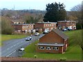
1
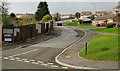
Drinkwater Gardens, Gaer, Newport
Drinkwater Gardens climbs away from Masefield Vale towards Gaer Road.
For more than 50 years, until the early 21st century, dwellings along Drinkwater Gardens were prefabs (prefabricated bungalows). A total of 750 prefabs were erected in various parts of Newport to meet a severe housing shortage after the Second World War.
The fencing on the left of the photo encloses a currently derelict area formerly occupied by prefabs. Elsewhere, modern bungalows have replaced the prefabs.
Image: © Jaggery
Taken: 3 Dec 2009
0.03 miles
2
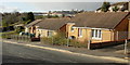
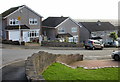
Masefield Vale, Gaer, Newport
Modern bungalows on the northern side of Masefield Vale, near the Drinkwater Gardens junction. For more than 50 years, until the early 21st century, the dwellings along Masefield Vale were prefabs (prefabricated bungalows). A total of 750 prefabs were erected in various parts of Newport to meet a severe housing shortage after the Second World War.
Image: © Jaggery
Taken: 3 Dec 2009
0.04 miles
3
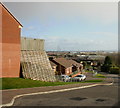
Looking down Drinkwater Gardens, Gaer, Newport
The view down Drinkwater Gardens, from near a retaining wall. http://www.geograph.org.uk/photo/1606198
For more than 50 years, until the early 21st century, dwellings along Drinkwater Gardens were prefabs (prefabricated bungalows). A total of 750 prefabs were erected in various parts of Newport to meet a severe housing shortage after the Second World War.
Image: © Jaggery
Taken: 3 Dec 2009
0.04 miles
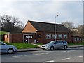
5
Shakespeare Crescent and Gaer Baptist Church, Newport
A view only recently made possible by the clearing of the foreground land in preparation for future development.
For a side view of the church see http://www.geograph.org.uk/photo/2293905 .
Image: © Robin Drayton
Taken: 10 Mar 2016
0.06 miles
6
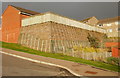
Retaining wall, Drinkwater Gardens, Gaer, Newport
On the east side of the steeply-inclined Drinkwater Gardens, http://www.geograph.org.uk/photo/1606201 a retaining wall encloses the garden of the adjoining house.
Image: © Jaggery
Taken: 3 Dec 2009
0.06 miles
7
Lansdowne Road, Newport
Houses on the east side of Lansdowne Road, viewed from Gaer Road.
Image: © Jaggery
Taken: 3 Dec 2009
0.06 miles
8
Polling Station 3rd March 2011, Newport
Gaer Baptist Church being used as a polling station for the referendum on whether greater law making powers be given to the Welsh Assembly in Cardiff.
For Wales overall there was a 35.4% turnout with a 63.5% Yes vote.
Newport had a 27.8% turnout with a 54.8% Yes vote.
Image: © Robin Drayton
Taken: 3 Mar 2011
0.06 miles
9
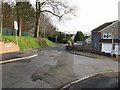
Gaer Road becomes a footpath, Newport
A short distance beyond this junction with Lansdowne Road, Gaer Road can be seen narrowing to a footpath. The footpath continues for about 100 metres southeastwards before widening into a road again at the far end of Lansdowne Road, to continue as Gaer Road down to Cardiff Road.
Image: © Jaggery
Taken: 3 Dec 2009
0.07 miles
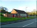
10
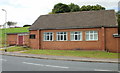
Gaer Baptist Church, Newport
On Shakespeare Crescent, near the junction with Masefield Vale.
Image: © Jaggery
Taken: 1 Oct 2009
0.07 miles