IMAGES TAKEN NEAR TO
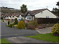
Copper Beech Close, NEWPORT, NP18 3RS
Introduction
This page details the photographs taken nearby to Copper Beech Close, NP18 3RS by members of the Geograph project.
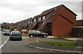
The Geograph project started in 2005 with the aim of publishing, organising and preserving representative images for every square kilometre of Great Britain, Ireland and the Isle of Man.

There are currently over 7.5m images from over14,400 individuals and you can help contribute to the project by visiting https://www.geograph.org.uk
Image Map
Images are licensed for reuse under creativecommons.org/licenses/by-sa/2.0
Notes
- Clicking on the map will re-center to the selected point.
- The higher the marker number, the further away the image location is from the centre of the postcode.
Image Listing (110 Images Found)
Images are licensed for reuse under creativecommons.org/licenses/by-sa/2.0
Image
Details
Distance
1
Pear Tree Close, Caerleon
Bungalows on the east side of Pear Tree Close. The view is from the far end of the close, looking towards Roman Reach.
Image: © Jaggery
Taken: 5 Apr 2010
0.05 miles
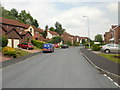
2
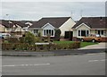
Caerleon : Wentwood Road bungalows
Located on the corner of Wentwood Road and Roman Reach.
Image: © Jaggery
Taken: 5 Apr 2010
0.05 miles
3
Conifer Close, Caerleon
Viewed from the Wentwood Road end. There is a mixture of bungalows and two-storey houses in the close. The choice of 'Conifer', a tree type, is somewhat out of kilter with most of the neighbouring streets which are named after specific trees.
Image: © Jaggery
Taken: 14 Jun 2010
0.06 miles
4
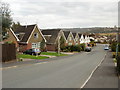
Matching roofs, Roman Reach, Caerleon
There are different colours but the same design of roof in this line of Roman Reach houses, SE of the turning for Walnut Drive.
Image: © Jaggery
Taken: 5 Apr 2010
0.08 miles
5
Unusually low roofs, Roman Reach, Caerleon
Roofs extend almost to ground level on houses on the south side of the southern section of Roman Reach, opposite Redwood Close and Hazel Walk
Image: © Jaggery
Taken: 5 Apr 2010
0.08 miles
6
Path north to Chestnut Grove, Caerleon
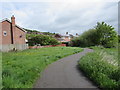
The path connects the combined footpath & cycle route (part of National Cycle Network route 88)
from Malpas to Caerleon with Chestnut Grove. http://www.geograph.org.uk/photo/4472178
Image: © Jaggery
Taken: 12 May 2015
0.08 miles
7
Chestnut Grove, Caerleon
Houses at the SW edge of Caerleon.
Image: © Jaggery
Taken: 12 May 2015
0.09 miles
8
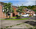
Hornbeam Close, Caerleon
Viewed from Wentwood Road.
Image: © Jaggery
Taken: 14 Jun 2010
0.09 miles
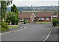
9
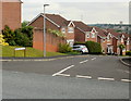
Northern section of Wentwood Road, Caerleon
Viewed from the corner of Hornbeam Close.
Image: © Jaggery
Taken: 14 Jun 2010
0.09 miles
10
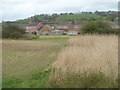
Edge of the reeds, Malpas to Caerleon cycleway
On the Caerleon side of the cycleway and footpath from Malpas, there is a sharp dividing line between a 200-metre long area of reeds, and a grassy area.
Image: © Jaggery
Taken: 14 Apr 2011
0.09 miles