IMAGES TAKEN NEAR TO
Glyn View, CHEPSTOW, NP16 6TN
Introduction
This page details the photographs taken nearby to Glyn View, NP16 6TN by members of the Geograph project.
The Geograph project started in 2005 with the aim of publishing, organising and preserving representative images for every square kilometre of Great Britain, Ireland and the Isle of Man.

There are currently over 7.5m images from over14,400 individuals and you can help contribute to the project by visiting https://www.geograph.org.uk
Image Map (Loading...)


Getting Data...Please wait
Leaflet Map data © OpenStreetMap
Images are licensed for reuse under creativecommons.org/licenses/by-sa/2.0
Notes
- Clicking on the map will re-center to the selected point.
- The higher the marker number, the further away the image location is from the centre of the postcode.
Image Listing (23 Images Found)
Images are licensed for reuse under creativecommons.org/licenses/by-sa/2.0
Image
Details
Distance
1
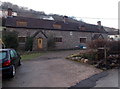
Crown Cottages in the Angiddy Valley near Tintern
Semi-detached cottages alongside Angiddy Brook. A royal crest and the year 1904 are on the wall.
Image: © Jaggery
Taken: 19 Jan 2014
0.03 miles
2
Postbox in the Angiddy Valley near Tintern
The red postbox on a wooden post is near these http://www.geograph.org.uk/photo/3986231 recently-built houses.
Image: © Jaggery
Taken: 19 Jan 2014
0.06 miles
3
Row of recently-built houses in the Angiddy Valley near Tintern
Row of 4 houses built in the first decade of the 21st century.
Image: © Jaggery
Taken: 19 Jan 2014
0.06 miles
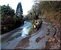
4
Unsuitable route for heavy goods vehicles near Tintern
Viewed from a junction in the Angiddy Valley.
Image: © Jaggery
Taken: 19 Jan 2014
0.06 miles
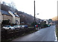
5
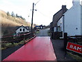
Icy red ramp near a road junction in the Angiddy Valley near Tintern
The railings on the left provided very useful when I found that there was a thin sheet of ice covering the ramp. I didn't see any vehicles on this route, but wondered how they would fare crossing this ramp...
Image: © Jaggery
Taken: 19 Jan 2014
0.08 miles
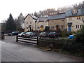
6
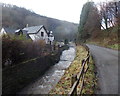
House, brook and road in the Angiddy Valley near Tintern
The Angiddy flows vigorously in mid-January 2014 in what was to be the wettest winter on record in many parts of the UK.
Image: © Jaggery
Taken: 19 Jan 2014
0.08 miles
7
Across Barbadoes Hill
A track descends across steep ground towards Tintern.
Image: © Richard Webb
Taken: 6 May 2012
0.11 miles
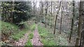
8
Path to Lower Hale Wood near Tintern
The path climbs away from the Angiddy Valley towards Lower Hale Wood on Barbadoes Hill.
Image: © Jaggery
Taken: 19 Jan 2014
0.13 miles
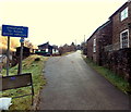
9
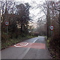
Start of the 30mph maximum speed zone at the western edge of Tintern
The speed limit along a road descending through the Angiddy Valley decreases to 30mph from the National Speed Limit.
Image: © Jaggery
Taken: 19 Jan 2014
0.15 miles
10
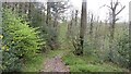
Woodland, Tintern
In common with most places where there was an iron industry, oak woods survive here. Charcoal burners did not destroy their living. The steep hillsides have lots of flat platforms where the charcoal ovens were situated.
The nearer you get to the village the more likely it is that a mapped path exists. Many mapped paths (OS and Bristol Orienteering Klub) further up the hillside have disappeared under brambles.
Image: © Richard Webb
Taken: 6 May 2012
0.15 miles