IMAGES TAKEN NEAR TO
Sunnyvale, USK, NP15 2EF
Introduction
This page details the photographs taken nearby to Sunnyvale, NP15 2EF by members of the Geograph project.
The Geograph project started in 2005 with the aim of publishing, organising and preserving representative images for every square kilometre of Great Britain, Ireland and the Isle of Man.

There are currently over 7.5m images from over14,400 individuals and you can help contribute to the project by visiting https://www.geograph.org.uk
Image Map
Images are licensed for reuse under creativecommons.org/licenses/by-sa/2.0
Notes
- Clicking on the map will re-center to the selected point.
- The higher the marker number, the further away the image location is from the centre of the postcode.
Image Listing (256 Images Found)
Images are licensed for reuse under creativecommons.org/licenses/by-sa/2.0
Image
Details
Distance
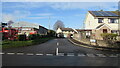
1
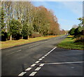
Road through the western edge of Raglan, Monmouthshire
Viewed from the Usk Road junction looking towards the A40 junction 500 metres from the camera.
Image: © Jaggery
Taken: 22 Nov 2020
0.02 miles
2
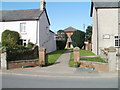
Raglan Baptist Church
The church is set back 40 metres from the NW side of Usk Road. The Fellowship Centre (used as a church hall) is next door, on the right. http://www.geograph.org.uk/photo/2087719
Image: © Jaggery
Taken: 26 Sep 2010
0.03 miles
3

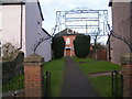
Raglan Baptist Fellowship Centre
Located on Usk Road, Raglan, next door to the church. http://www.geograph.org.uk/photo/2087715
Used throughout the week for regular social events, such as Mothers and Toddlers on Monday mornings, and Seniors Lunch Club on Thursdays.
Image: © Jaggery
Taken: 26 Sep 2010
0.03 miles
5
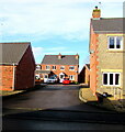
Residential side road in Raglan, Monmouthshire
Set back from Usk Road.
Image: © Jaggery
Taken: 22 Nov 2020
0.04 miles
6
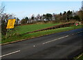
Yellow temporary sign on the approach to the A40, Raglan, Monmouthshire
Viewed on November 22nd 2020. Text includes "A449 Closed at Raglan. Follow (signs with a white star symbol)". The text is also in Welsh.
Image: © Jaggery
Taken: 22 Nov 2020
0.04 miles
7
Rooftop solar panels in Raglan, Monmouthshire
Viewed across Usk Road in November 2020.
Image: © Jaggery
Taken: 22 Nov 2020
0.05 miles
8
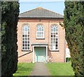
Baptist Chapel, Raglan
The 'new' Baptist Chapel was built in 1862. "The chapel is calculated to accommodate a congregation of about 300 persons, and, in point of architecture, present. a rare combination of elegance and economy" (source: Illustrated Usk Observer and Raglan Herald, 12/04/1862, Welsh Newspapers on line). My aim is to cycle to all the churches and chapels in a 25km radius of my home.
Image: © Andy Stott
Taken: 9 Apr 2015
0.06 miles

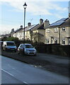
10
Along Sunnyvale, Raglan, Monmouthshire
The southeast part of dead end Sunnyvale viewed across Usk Road in November 2020.
Most references show Sunnyvale, though the name sign on the right shows Sunny Vale.
Image: © Jaggery
Taken: 22 Nov 2020
0.06 miles