IMAGES TAKEN NEAR TO
The Pitt, Raglan, USK, NP15 2AP
Introduction
This page details the photographs taken nearby to NP15 2AP by members of the Geograph project.
The Geograph project started in 2005 with the aim of publishing, organising and preserving representative images for every square kilometre of Great Britain, Ireland and the Isle of Man.

There are currently over 7.5m images from over14,400 individuals and you can help contribute to the project by visiting https://www.geograph.org.uk
Image Map
Images are licensed for reuse under creativecommons.org/licenses/by-sa/2.0
Notes
- Clicking on the map will re-center to the selected point.
- The higher the marker number, the further away the image location is from the centre of the postcode.
Image Listing (14 Images Found)
Images are licensed for reuse under creativecommons.org/licenses/by-sa/2.0
Image
Details
Distance
1
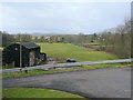
Pasture land beyond New House Farm
Beyond in the distance are (left to right) Ysgyryd Fach, Y Fal (Sugarloaf) and Ysgyryd Fawr (Skirrid).
Image: © Jonathan Billinger
Taken: 28 Jan 2010
0.09 miles
2
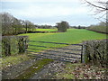
Pastures by the Clawdd Brook
Looking east alongside the A40 between Raglan and Abergavenny
Image: © Jonathan Billinger
Taken: 28 Jan 2010
0.11 miles
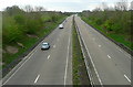
3
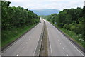
The A40 near Clytha
View to the west along the A40 from a bridge near Clytha.
Image: © Philip Halling
Taken: 9 Jun 2012
0.14 miles
4
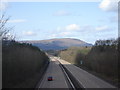
The A40 towards Abergavenny
Picture taken from bridge near Pit Clytha Farm. The hill in the distance is Blorenge, max height 552m.
Image: © Ruth Sharville
Taken: 13 Mar 2007
0.15 miles
5
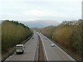
A40 heading west
In the distance, lit by weak winter sunshine, is Blorenge, 559m.
Image: © Jonathan Billinger
Taken: 28 Jan 2010
0.15 miles
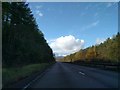
6
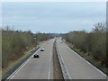
A40 looking east
This dual carriageway is one of the less-used trunk roads in the UK.
Image: © Jonathan Billinger
Taken: 28 Jan 2010
0.16 miles
7
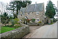
House at Pit
Just because, as I drove through the village, I saw it and liked it.
Image: © Graham Horn
Taken: 13 Apr 2012
0.18 miles
8
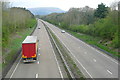
A40 towards Abergavenny
Blorenge Image in the background. This long dual carriageway section from Raglan to Abergavenny was built in the 1970s, and crosses the old route a number of times.
Image: © Graham Horn
Taken: 13 Apr 2012
0.18 miles
10
A40 towards Raglan
This long dual carriageway section from Abergavenny to Raglan was built in the 1970s, and crosses the old route a number of times.
Image: © Graham Horn
Taken: 13 Apr 2012
0.21 miles