IMAGES TAKEN NEAR TO
Railway Court, Heolddu Road, BLACKWOOD, NP12 2HS
Introduction
This page details the photographs taken nearby to Railway Court, Heolddu Road, NP12 2HS by members of the Geograph project.
The Geograph project started in 2005 with the aim of publishing, organising and preserving representative images for every square kilometre of Great Britain, Ireland and the Isle of Man.

There are currently over 7.5m images from over14,400 individuals and you can help contribute to the project by visiting https://www.geograph.org.uk
Image Map
Images are licensed for reuse under creativecommons.org/licenses/by-sa/2.0
Notes
- Clicking on the map will re-center to the selected point.
- The higher the marker number, the further away the image location is from the centre of the postcode.
Image Listing (64 Images Found)
Images are licensed for reuse under creativecommons.org/licenses/by-sa/2.0
Image
Details
Distance
1
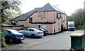
The Halfway House, Upper Gelligroes, Pontllanfraith
Restaurant and pub, with accommodation available. Located on an unnamed lane on the north side of Heolddu Road.
Image: © Jaggery
Taken: 7 Apr 2011
0.03 miles
2
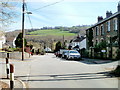
Looking down Heolddu Road, Gelligroes
Looking towards Newport Road (B4251), viewed from the left turn for The Halfway House. http://www.geograph.org.uk/photo/2359575
Image: © Jaggery
Taken: 7 Apr 2011
0.04 miles
3
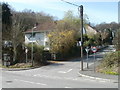
Corner of Newport Road and Heol Ddu Road, Gelligroes, Pontllanfraith
A 30mph speed limit applies along Heol Ddu Road. Heol Ddu is Welsh for Black Road, so the English word Road appears to be a tautology here.
Image: © Jaggery
Taken: 7 Apr 2011
0.04 miles
4
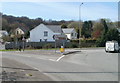
Left for Ynysddu at the Gelligroes Roundabout, Pontllanfraith
Viewed from the edge of the A472. The B4251 (Newport Road) heads south from Gelligroes Roundabout towards Ynysddu and the Sirhowy Valley Country Park.
Image: © Jaggery
Taken: 7 Apr 2011
0.04 miles
5
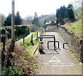
Cycle route heads south, Upper Gelligroes
National Cycle Network route 47 viewed from the edge of Heolddu Road.
Image: © Jaggery
Taken: 7 Apr 2011
0.06 miles
6

Left for Wyllie, Upper Gelligroes
At the top of Heolddu Road, a left turn into Wyllie Road leads to the hamlet of Wyllie, a quarter of a mile away.
Image: © Jaggery
Taken: 7 Apr 2011
0.06 miles
7
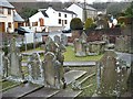
Churchyard, Siloh Presbyterian Church, Gelligroes
http://www.geograph.org.uk/photo/1772041 for the church.
Gelligroes means "the grove at the crossroads".
Image: © Robin Drayton
Taken: 20 Mar 2010
0.07 miles
8
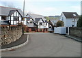
Central section of Gerddi Ty Mawr, Upper Gelligroes
Houses located near The Halfway House. http://www.geograph.org.uk/photo/2359575
Image: © Jaggery
Taken: 7 Apr 2011
0.07 miles
9
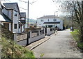
Houses at the northern end of Gerddi Ty Mawr, Upper Gelligroes
The northern end of the road named Gerddi Ty Mawr is near a footbridge http://www.geograph.org.uk/photo/2359581 over the A472.
The Halfway House http://www.geograph.org.uk/photo/2359575 is ahead, out of shot around the corner.
Image: © Jaggery
Taken: 7 Apr 2011
0.07 miles
10
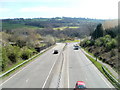
A472 approaches Gelligroes Roundabout
The view from a footbridge. http://www.geograph.org.uk/photo/2359581
Image: © Jaggery
Taken: 7 Apr 2011
0.07 miles