IMAGES TAKEN NEAR TO
Auckland Close, BLACKWOOD, NP12 0UW
Introduction
This page details the photographs taken nearby to Auckland Close, NP12 0UW by members of the Geograph project.
The Geograph project started in 2005 with the aim of publishing, organising and preserving representative images for every square kilometre of Great Britain, Ireland and the Isle of Man.

There are currently over 7.5m images from over14,400 individuals and you can help contribute to the project by visiting https://www.geograph.org.uk
Image Map
Images are licensed for reuse under creativecommons.org/licenses/by-sa/2.0
Notes
- Clicking on the map will re-center to the selected point.
- The higher the marker number, the further away the image location is from the centre of the postcode.
Image Listing (68 Images Found)
Images are licensed for reuse under creativecommons.org/licenses/by-sa/2.0
Image
Details
Distance
1
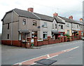
Oakdale Terrace houses, Penmaen
The houses are at the southern end of Oakdale Terrace, alongside the main road through Penmaen.
Image: © Jaggery
Taken: 8 Aug 2012
0.04 miles
2
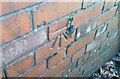
Ordnance Survey Cut Mark
This OS cut mark can be found on No1 Oakdale Terrace. It marks a point 194.731m above mean sea level.
Image: © Adrian Dust
Taken: 9 Feb 2021
0.06 miles
3
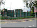
SE corner of Oakdale Comprehensive School
Viewed across Penmaen Road. The games court is part of a large area in the southern part of the school site allocated for sports use.
Image: © Jaggery
Taken: 8 Aug 2012
0.06 miles
4
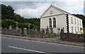
Former Penmain chapel, Penmaen
Located on the east side of Oakdale Terrace, the former Penmain chapel has been the practice rooms of Mynyddislwyn Male Choir since 1992. Their name appears on the entrance gates. The spelling Penmain is an Anglicised form of Penmaen.
The tablet above the front windows shows (in Welsh) that the chapel was built in 1694, rebuilt in 1829 and renovated in 1888. The top line of the tablet is 1639_40, perhaps indicating when construction of the chapel began, in which case the Welsh "adeiladwyd 1694", literally "was built in 1694" should be understood to mean "was completed in 1694"
Image: © Jaggery
Taken: 8 Aug 2012
0.06 miles
5
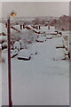
Canberra Close, Penmaen after heavy snow
Residential road on housing estate.
Image: © M J Roscoe
Taken: Unknown
0.08 miles
6
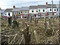
Penmain Chapel yard
Work has commenced in clearing this very overgrown chapel yard. The houses opposite are in Oakdale Terrace.
Image: © Robin Drayton
Taken: 5 Apr 2008
0.09 miles
7
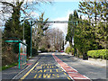
Bus stop and bat crossing, Oakdale Terrace, Penmaen
With the construction of the nearby Sirhowy Enterprise Way, several bat crossings were constructed in the area to mitigate for the loss of an old railway bridge.
Image: © Robin Drayton
Taken: 5 Apr 2008
0.10 miles
8
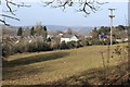
Rear of Penmaen Chapel
Former chapel (white) now the base for a choir, viewed from the hillside. The pasture in the foreground is viewed from behind the chapel in Image A little used footpath Image crosses the pasture from the rear of the chapel.
Image: © M J Roscoe
Taken: 14 Mar 2016
0.10 miles
9
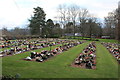
Garden of Remembrance, Woodfield Park
Memorial garden next to the funeral home Image visible in the background.
Image: © M J Roscoe
Taken: 1 Jan 2019
0.10 miles
10
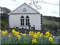
Penmain Chapel
Penmain Chapel was built in 1694, rebuilt in 1829 and renovated in 1888. The congregation that first worshipped here was established by Henry Walter http://yba.llgc.org.uk/en/s-WALT-HEN-1611.html?query=henry+walter&field=name and was one of the earliest nonconformist congregations in Wales.
Image: © Robin Drayton
Taken: 5 Apr 2008
0.10 miles