IMAGES TAKEN NEAR TO
Pont Gwaith Yr Haearn Farm Lane, BLACKWOOD, NP12 0RP
Introduction
This page details the photographs taken nearby to Pont Gwaith Yr Haearn Farm Lane, NP12 0RP by members of the Geograph project.
The Geograph project started in 2005 with the aim of publishing, organising and preserving representative images for every square kilometre of Great Britain, Ireland and the Isle of Man.

There are currently over 7.5m images from over14,400 individuals and you can help contribute to the project by visiting https://www.geograph.org.uk
Image Map
Images are licensed for reuse under creativecommons.org/licenses/by-sa/2.0
Notes
- Clicking on the map will re-center to the selected point.
- The higher the marker number, the further away the image location is from the centre of the postcode.
Image Listing (20 Images Found)
Images are licensed for reuse under creativecommons.org/licenses/by-sa/2.0
Image
Details
Distance
1
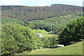
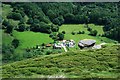
Pont Gwaithyrhaearn Farmhouse, from A4048
A farm down in the floor of the Upper Sirhowy Valley north of Hollybush, with Coed Llanerch behind on the hillside.
Image: © M J Roscoe
Taken: 3 Jun 2016
0.01 miles
2
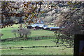
Pont Gwaithyrhaearn Farm, Upper Sirhowy Valley
Farmhouse and stables seen from the Sirhowy Valley Walk (western alternative). The woodland in the background is on the other side off the River Sirhowy.
Image: © M J Roscoe
Taken: 10 Nov 2016
0.01 miles
3
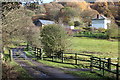
Pont Gwaithyrhaearn Farm north of Hollybush
Viewed from the A4048 Newport Road through a gap in the trees.
Image: © Jaggery
Taken: 6 Jul 2013
0.01 miles
4
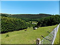
Pont Gwaithyrhaearn Farm, Upper Sirhowy Valley (2)
Seen from near the bridge that gives its name to the farm; for a distant summer view of the farm, see Image On the hillside behind is part of Coed y Llanerch
Image: © M J Roscoe
Taken: 10 Nov 2016
0.01 miles
5
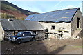
Outbuilding renovation, Pont Gwaithyrhaearn Farm
Stone outbuilding undergoing renovation.
Image: © M J Roscoe
Taken: 10 Nov 2016
0.02 miles
6
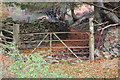
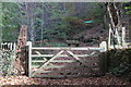
Sirhowy Valley Walk, Pont Gwaithyrhaearn
The track is a public footpath, but the gate is locked! This part of the Walk is on the western alternative route through the Upper Sirhowy Valley Community Woodlands.
Image: © M J Roscoe
Taken: 10 Nov 2016
0.05 miles
7
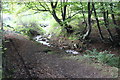
Nant yr Helyg, Pont Gwaithyrhaern
Stream, tributary of the River Sirhowy, alongside a track, part of the Sirhowy Valley Walk, to the entrance to Coed y Llanerch Image (behind camera).
Image: © M J Roscoe
Taken: 15 Oct 2017
0.06 miles
9
Entrance to Upper Sirhowy Valley Community Woodlands
Gated entrance on the Sirhowy Valley Walk (western alternative) Pontgwaithyrhaearn Farm; the iron sculpture and adjoining sandstone wall is characteristic of the main entrances to the Woodlands. Each sculpture portrays a different aspect of the area.
Image: © M J Roscoe
Taken: 10 Nov 2016
0.08 miles
10
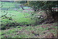
Stream, Pont Gwaithyrhaeryn
Unnamed stream, a tributary of the Nant yr Helyg, viewed from the Sirhowy Valley Walk (alternative route).
Image: © M J Roscoe
Taken: 15 Oct 2017
0.08 miles