IMAGES TAKEN NEAR TO
Syr Dafydd Avenue, BLACKWOOD, NP12 0LA
Introduction
This page details the photographs taken nearby to Syr Dafydd Avenue, NP12 0LA by members of the Geograph project.
The Geograph project started in 2005 with the aim of publishing, organising and preserving representative images for every square kilometre of Great Britain, Ireland and the Isle of Man.

There are currently over 7.5m images from over14,400 individuals and you can help contribute to the project by visiting https://www.geograph.org.uk
Image Map
Images are licensed for reuse under creativecommons.org/licenses/by-sa/2.0
Notes
- Clicking on the map will re-center to the selected point.
- The higher the marker number, the further away the image location is from the centre of the postcode.
Image Listing (83 Images Found)
Images are licensed for reuse under creativecommons.org/licenses/by-sa/2.0
Image
Details
Distance
1
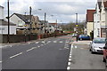
Zebra crossing, Syr Dafydd Avenue, Oakdale
New flat top hump with zebra crossing in new 20mph zone, completed early April 2016. This is part of a new Safe Routes Project near the two primary schools in Oakdale.
Image: © M J Roscoe
Taken: 8 Apr 2016
0.04 miles
2
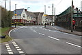
Belisha beacons, Syr Dafydd Avenue, Oakdale
New zebra crossing and realigned kerb next to Ysgol Gymraeg Cwm Derwen (boundary wall on right), completed in early April 2015. This is part of a Safe Routes Project, Image
Image: © M J Roscoe
Taken: 8 Apr 2016
0.08 miles
3
Rebuilding Pen-Rhiw Bengi Farm
Rear of buildings and garden, pasture in foreground; front view of renovation of outbuildings - Image
Image: © M J Roscoe
Taken: 4 May 2020
0.09 miles
4
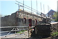
Renovating Pen-Rhiw Bengi Farm
Almost total rebuild of the farm's outbuildings; the attached dwelling is to the right, with roof removed.
Image: © M J Roscoe
Taken: 25 Apr 2020
0.09 miles
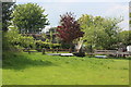
5
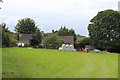
Pen-rhiw Bengi Farm, Oakdale
Farmhouse is building on left (with washing on line)
Image: © M J Roscoe
Taken: 16 Aug 2015
0.09 miles
6
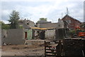
Rebuilding Pen-Rhiw Bengi Farm (2)
The stone outhouses Image attached to the house have been completely demolished to make way for new building. The large hole in the wall marks the position of the main fireplace.
Image: © M J Roscoe
Taken: 13 May 2020
0.09 miles
7
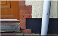
Ordnance Survey Cut Mark
This OS cut mark can be found on No2 Aberconway Place. It marks a point 249.195m above mean sea level.
Image: © Adrian Dust
Taken: 9 Feb 2021
0.10 miles
8
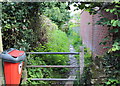
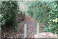
Footpath from Pen-rhiw Bengi Lane, Oakdale
Field footpath, with edge of new housing estate on the right.
Image: © M J Roscoe
Taken: 10 Aug 2015
0.10 miles
9
Pen-rhiw Bengi Lane, Oakdale
The lane is now a cul-de-sac and this lower section is closed to vehicular traffic. In the past it dipped down to the valley floor and up to Gwrhay.
Image: © M J Roscoe
Taken: 16 Nov 2015
0.13 miles
10
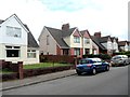
Aberconway Place houses, Oakdale
Viewed from the Markham Crescent end.
Image: © Jaggery
Taken: 8 Aug 2012
0.14 miles