IMAGES TAKEN NEAR TO
Ty Brachty Terrace, NEWPORT, NP11 3BU
Introduction
This page details the photographs taken nearby to Ty Brachty Terrace, NP11 3BU by members of the Geograph project.
The Geograph project started in 2005 with the aim of publishing, organising and preserving representative images for every square kilometre of Great Britain, Ireland and the Isle of Man.

There are currently over 7.5m images from over14,400 individuals and you can help contribute to the project by visiting https://www.geograph.org.uk
Image Map
Images are licensed for reuse under creativecommons.org/licenses/by-sa/2.0
Notes
- Clicking on the map will re-center to the selected point.
- The higher the marker number, the further away the image location is from the centre of the postcode.
Image Listing (33 Images Found)
Images are licensed for reuse under creativecommons.org/licenses/by-sa/2.0
Image
Details
Distance
1
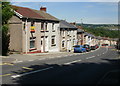
Ty-Brachty Terrace
A long line of terraced houses named Ty-Brachty Terrace descends Kendon Road (B4251) in the direction of Crumlin. It's unclear from maps whether this is the northern edge of Croespenmaen or the southern edge of Kendon.
Image: © Jaggery
Taken: 23 Jun 2010
0.05 miles
2
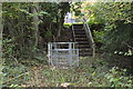
Steps on path to lane at the end of Ty-Brachty Terrace, Kendon
The steps, part of public footpath, replace a scramble up the slope from the edge of a playing field
Image: © M J Roscoe
Taken: 23 Oct 2015
0.05 miles
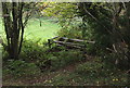
3
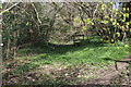
Stile behind Ty-Brachty Terrace, Kendon
Stile in isolation on overgrown hillside footpath. There is a bed of bluebells in bud below the stile.
Image: © M J Roscoe
Taken: 30 Apr 2016
0.06 miles
4
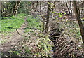
Stream behind Ty-Brachty Terrace, Kendon
Stream running down the side of an old colliery waste tip. There is a bed of bluebells in bud to the left.
Image: © M J Roscoe
Taken: 30 Apr 2016
0.06 miles
5
Footbridge on path to Ty-Brachty Terrace, Kendon
The field footpath comes downhill, goes over the wooden bridge, over the stile, and turns right along the edge of a playing field to the metal gate seen in Image
Image: © M J Roscoe
Taken: 23 Oct 2015
0.06 miles
6
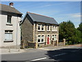
Caer-ynys-isha, Kendon Road,Crumlin
A detached house at the eastern end of a long row of terraced houses on Ty-Brachty Terrace.http://www.geograph.org.uk/photo/1931777
Image: © Jaggery
Taken: 23 Jun 2010
0.06 miles
7
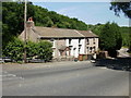
White Cottages, Kendon Road
Three cottages named White Cottages, but two of them are currently asserting their right to an existence unfettered by convention.
Image: © Jaggery
Taken: 23 Jun 2010
0.12 miles
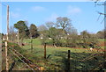
8
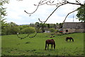
Paddock, Lower Ton-y-felin Farm
Horses graze close to somewhat dilapidated farm buildings. The houses beyond, across the head of the valley, are in Croespenmaen
Image: © M J Roscoe
Taken: 15 May 2016
0.12 miles
9
Lower Ton-y-Felin, Croespenmaen
A field footpath runs along the left of the wire fence
Image: © M J Roscoe
Taken: 6 Jan 2016
0.13 miles
10
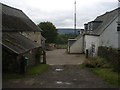
Farmyard, Lower Ton-y-Felin
Yard at rear of house.
Image: © M J Roscoe
Taken: 15 Jul 2015
0.13 miles