IMAGES TAKEN NEAR TO
St. Georges Avenue, NORTHAMPTON, NN2 6JB
Introduction
This page details the photographs taken nearby to St. Georges Avenue, NN2 6JB by members of the Geograph project.
The Geograph project started in 2005 with the aim of publishing, organising and preserving representative images for every square kilometre of Great Britain, Ireland and the Isle of Man.

There are currently over 7.5m images from over14,400 individuals and you can help contribute to the project by visiting https://www.geograph.org.uk
Image Map
Images are licensed for reuse under creativecommons.org/licenses/by-sa/2.0
Notes
- Clicking on the map will re-center to the selected point.
- The higher the marker number, the further away the image location is from the centre of the postcode.
Image Listing (10 Images Found)
Images are licensed for reuse under creativecommons.org/licenses/by-sa/2.0
Image
Details
Distance
1
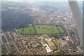
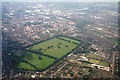
Northampton University and old racecourse: aerial 2014
St. Georges Avenue campus.
The Racecourse comprises about 118 acres and is now a recreation ground. It once staged regular horse racing meetings, but these ceased in 1904 owing to the high accident rate due to the sharp turns on the course.
Picture taken from about 3,000 ft by the "Child with the Dandelion Clock": Image
Image: © Chris
Taken: 2 Jul 2014
0.05 miles
2
Northampton University
Avenue Campus.
Image: © Burgess Von Thunen
Taken: 7 Jun 2012
0.08 miles
3
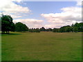
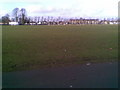
The Racecourse
Looking across football pitches to St Georges Avenue.
Image: © Burgess Von Thunen
Taken: 1 Feb 2011
0.13 miles
4
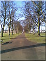
The Racecourse
A path leading to St George's Avenue.
Image: © Burgess Von Thunen
Taken: 1 Feb 2011
0.16 miles
5
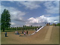
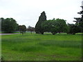
The Racecourse
Part of a new playground. Apparently the grass is yet to take hold.
Image: © Burgess Von Thunen
Taken: 15 May 2010
0.19 miles
6
The Racecourse and Northampton SW: aerial 2014
Taken by the "Child with the Dandelion Clock" Image
The Racecourse comprises about 118 acres and is now a recreation ground. It once staged regular horse racing meetings, but these ceased in 1904 owing to the high accident rate due to the sharp turns on the course.
Bottom right is the St. Georges Avenue campus of Northampton University.
River Nene and Express Lifts Tower top right.
Racecourse history: From 1632, unofficial race meetings were held at Northampton Heath, the name originally given to the area including the Racecourse.
The park is believed to have been used from 1778 to 1882 as an area where freemen had grazing rights under the 1778 Act of Enclosure. Between these dates the Racecourse was known simply as the Freeman's Common. In 1882 when Commoners lost their right to graze cattle, the land was sold on by the Northampton Corporation Act. The park was then used by the public as a general recreation ground.
Race meetings resumed in 1727, with the help of Lord Spencer, and in 1737 the first official race meet was held on the new course.
From 1715 to 1818, the park was frequently used for public executions.
http://en.wikipedia.org/wiki/The_Racecourse,_Northampton
Image: © Chris
Taken: 2 Jul 2014
0.20 miles
7
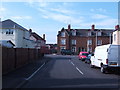
Junction of Randall Road with Kingsley Road, Northampton
Image: © Jonathan Billinger
Taken: 5 Apr 2007
0.22 miles
8
The Racecourse
A hilly bit in the middle of the mostly flat Racecourse. In the 1930s and 1940s this area was known as 'Happy Valley'. At one time it contained a children's playground. It was formed by the bed of a stream that ran off the racecourse, down under St Georges Avenue, past the end of Freehold Street and down into the Walbeck. The bed was filled in and raised by unemployed workers (demobilised soldiers) in 1920, 1921 after WW1.
Image: © Burgess Von Thunen
Taken: 9 Aug 2011
0.22 miles
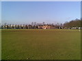
9
The Racecourse
This is a cricket pitch in the summer.
Image: © Burgess Von Thunen
Taken: 1 Feb 2011
0.24 miles
10
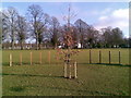
The Racecourse
New tree near the new play area.
Image: © Burgess Von Thunen
Taken: 1 Feb 2011
0.24 miles