The Racecourse and Northampton SW: aerial 2014
Introduction
The photograph on this page of The Racecourse and Northampton SW: aerial 2014 by Chris as part of the Geograph project.
The Geograph project started in 2005 with the aim of publishing, organising and preserving representative images for every square kilometre of Great Britain, Ireland and the Isle of Man.

There are currently over 7.5m images from over 14,400 individuals and you can help contribute to the project by visiting https://www.geograph.org.uk
The Racecourse and Northampton SW: aerial 2014
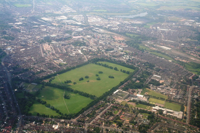
Image: © Chris Taken: 2 Jul 2014
Taken by the "Child with the Dandelion Clock" Image The Racecourse comprises about 118 acres and is now a recreation ground. It once staged regular horse racing meetings, but these ceased in 1904 owing to the high accident rate due to the sharp turns on the course. Bottom right is the St. Georges Avenue campus of Northampton University. River Nene and Express Lifts Tower top right. Racecourse history: From 1632, unofficial race meetings were held at Northampton Heath, the name originally given to the area including the Racecourse. The park is believed to have been used from 1778 to 1882 as an area where freemen had grazing rights under the 1778 Act of Enclosure. Between these dates the Racecourse was known simply as the Freeman's Common. In 1882 when Commoners lost their right to graze cattle, the land was sold on by the Northampton Corporation Act. The park was then used by the public as a general recreation ground. Race meetings resumed in 1727, with the help of Lord Spencer, and in 1737 the first official race meet was held on the new course. From 1715 to 1818, the park was frequently used for public executions. http://en.wikipedia.org/wiki/The_Racecourse,_Northampton
Images are licensed for reuse under creativecommons.org/licenses/by-sa/2.0
Image Location
Latitude
52.248338
Longitude
-0.888941