IMAGES TAKEN NEAR TO
Anfield Close, NOTTINGHAM, NG9 6FP
Introduction
This page details the photographs taken nearby to Anfield Close, NG9 6FP by members of the Geograph project.
The Geograph project started in 2005 with the aim of publishing, organising and preserving representative images for every square kilometre of Great Britain, Ireland and the Isle of Man.

There are currently over 7.5m images from over14,400 individuals and you can help contribute to the project by visiting https://www.geograph.org.uk
Image Map
Images are licensed for reuse under creativecommons.org/licenses/by-sa/2.0
Notes
- Clicking on the map will re-center to the selected point.
- The higher the marker number, the further away the image location is from the centre of the postcode.
Image Listing (44 Images Found)
Images are licensed for reuse under creativecommons.org/licenses/by-sa/2.0
Image
Details
Distance
1
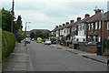
Rutland Road
One of the earliest new roads to be developed as part of the expansion of Toton as a dormitory residential area in the inter-war period.
Image: © Alan Murray-Rust
Taken: 24 Jun 2010
0.05 miles
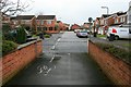
2
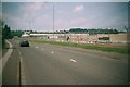
MOD buildings taken down for new housing and firms
Now built and moved into
Image: © Andy Jamieson
Taken: 22 Jun 2003
0.07 miles
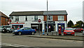
3
Toton Stores and Post Office
This is one of the older buildings in Toton which was little more than a hamlet until the development of housing in the inter- and post-war periods.
Image: © Alan Murray-Rust
Taken: 24 Jun 2010
0.07 miles
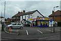
4
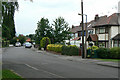
Stapleford Lane Post Office
Convenience stores on Stapleford Lane, Toton.
Image: © Mary and Angus Hogg
Taken: 18 Oct 2017
0.07 miles
5
Sustrans Route 6 in Toton
The route follows a quite convoluted path through the new estates in Toton to avoid the busy A6005 between Toton Corner and Attenborough where the main road is quite hostile with pavements quite unsuitable for being shared by pedestrians and cyclists.
Image: © David Lally
Taken: 25 Feb 2010
0.11 miles
6

St Peter's Church, Toton
The church was established in the 1920s as part of the parish of Attenborough, a situation that lasted until 2002 when a new parish of Toton was created. The building itself was consecrated in 1954.
Image: © Alan Murray-Rust
Taken: 24 Jun 2010
0.12 miles
7
Chetwynd Road
Now a residential backwater, it ran through to Chilwell High Road before the construction of the Chilwell Ordnance Depot.
Image: © Alan Murray-Rust
Taken: 24 Jun 2010
0.12 miles
8
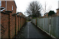
Kindlewood Drive
Taken from the end of a short path / cycleway between it and Norfolk Avenue.
This forms part of a rather tortuous route that Sustrans route 6 takes through the back-ways of Toton to avoid the busy A6005 between Toton Corner and Attenborough.
Image: © David Lally
Taken: 25 Feb 2010
0.13 miles
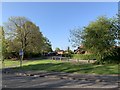
10
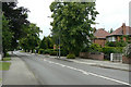
Stapleford Lane, Toton
This is historically the main road between Stapleford and Long Eaton. Toton developed in the inter- and post-war periods as a large dormitory suburb.
Image: © Alan Murray-Rust
Taken: 24 Jun 2010
0.14 miles