IMAGES TAKEN NEAR TO
Sandy Lane, NOTTINGHAM, NG9 3GT
Introduction
This page details the photographs taken nearby to Sandy Lane, NG9 3GT by members of the Geograph project.
The Geograph project started in 2005 with the aim of publishing, organising and preserving representative images for every square kilometre of Great Britain, Ireland and the Isle of Man.

There are currently over 7.5m images from over14,400 individuals and you can help contribute to the project by visiting https://www.geograph.org.uk
Image Map
Images are licensed for reuse under creativecommons.org/licenses/by-sa/2.0
Notes
- Clicking on the map will re-center to the selected point.
- The higher the marker number, the further away the image location is from the centre of the postcode.
Image Listing (40 Images Found)
Images are licensed for reuse under creativecommons.org/licenses/by-sa/2.0
Image
Details
Distance
1
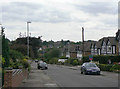
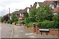
Sandy Lane
This section on the less steep southern slope of Bramcote Hills has succumbed to typical tudorbethan suburbia.
Image: © Alan Murray-Rust
Taken: 6 Sep 2009
0.02 miles
2
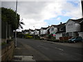
Markham Road, Bramcote Hills
Access to housing to the east of Sandy Lane developed during the late 1970s.
Image: © Alan Murray-Rust
Taken: 16 Apr 2014
0.07 miles
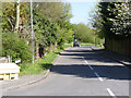
3
Sandy Lane, Bramcote Hills
Post-WW2 housing development off Derby Road. This road followed the line of an established track and is still marked as a bridleway on OS maps.
Image: © Alan Murray-Rust
Taken: 16 Apr 2014
0.09 miles
4

Wollaton from Bramcote Hills
Not much has changed since this 1978 view across Nottingham's western suburbs, although most of the shops in the middle distance have changed hands and the petrol filling station has gone.
Image: © Stephen McKay
Taken: Unknown
0.10 miles
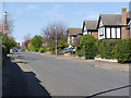
5
Sandringham Drive
Typical Inter-war suburban development off Derby Road.
Image: © Alan Murray-Rust
Taken: 6 Sep 2009
0.10 miles
6
Cranston Road, Bramcote Hills
Part of an estate of private housing built in the late 1950s/early 1960s. The houses here, on the north side of Cranston Road, back on to Alexandrina Plantation.
Image: © Stephen McKay
Taken: 1 Jul 2007
0.10 miles
7
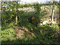
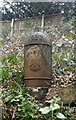
Nottingham Boundary Marker, Sandy Lane
Perched precariously on a steep slope, this is one of the markers established as part of the expansion of the City of Nottingham in 1933.
Image: © Alan Murray-Rust
Taken: 19 Apr 2014
0.14 miles
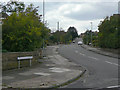
8
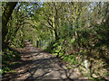
Sandy Lane, Bramcote Hills
An old established trackway through Bramcote Hills linking Beeston and Wollaton, here cutting through the Bunter sandstone of the scarp.
Image: © Alan Murray-Rust
Taken: 16 Apr 2014
0.14 miles
9
Sandy Lane, Bramcote
Seen from its junction with Derby Road. The white gabled parts of the houses in the foreground look almost superimposed on the rest of the architecture.
Image: © Richard Vince
Taken: 7 Jul 2012
0.14 miles
10
Old Boundary Marker on Alexandrina Plantation, Bramcote
Municipal Boundary Marker at the top of a steep slope, against a wire fence in Alexandrina Plantation Local Nature Reserve, off Sandy Lane in Bramcote. This marks the City of Nottingham boundary which absorbed Wollaton parish in 1933. See also https://www.geograph.org.uk/photo/3939857.
Milestone Society National ID: NT_NOT26pb
Image: © N Osmond
Taken: Unknown
0.14 miles