IMAGES TAKEN NEAR TO
Vale Crescent North, NOTTINGHAM, NG8 3PR
Introduction
This page details the photographs taken nearby to Vale Crescent North, NG8 3PR by members of the Geograph project.
The Geograph project started in 2005 with the aim of publishing, organising and preserving representative images for every square kilometre of Great Britain, Ireland and the Isle of Man.

There are currently over 7.5m images from over14,400 individuals and you can help contribute to the project by visiting https://www.geograph.org.uk
Image Map
Images are licensed for reuse under creativecommons.org/licenses/by-sa/2.0
Notes
- Clicking on the map will re-center to the selected point.
- The higher the marker number, the further away the image location is from the centre of the postcode.
Image Listing (58 Images Found)
Images are licensed for reuse under creativecommons.org/licenses/by-sa/2.0
Image
Details
Distance
1
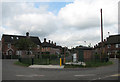
Ainsley Road: roundabout redevelopment
There have been changes since I was last here in August 2010 (Image]), but quite what they are in aid of is not clear, so I shall have to return.
Image: © John Sutton
Taken: 12 Jul 2011
0.06 miles
2

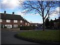
Northdown Road
Private houses were built at this end of the Ainsley Estate. The first of the council houses on Northdown Road are in the distance, where the road curves to the right. The Woodlands flats dominate the Radford skyline in the way the now demolished John Player & Sons cigarette factory once did. To their left is the spire of All Saints' Church, still further away.
Image: © John Sutton
Taken: 12 Jul 2011
0.06 miles
3

Ainsley Road and Vale Crescent
Image: © John Sutton
Taken: 27 Sep 2023
0.06 miles
4

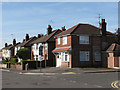
On Northdown Road
This estate was begun before the Second World War but not completed until after it.
Image: © John Sutton
Taken: 27 Sep 2023
0.06 miles
6

Ainsley Road
This small council estate to the east of Western Boulevard was laid out in the late 1930s. I wondered if this concrete structure was an air-raid shelter entrance, but my friend Tim Dale, who lived nearby in the fifties and sixties, thinks it is something to do with the drainage system.
Image: © John Sutton
Taken: 27 Aug 2010
0.07 miles
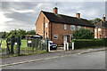
7
Grassington Road: former beer-off
This detached house on the corner of Grassington and Northdown Roads was, as the faded painted signs for Whitbread and Guinness show, once a corner off-licence (or beer-off, as Nottinghamians called them). In the High and Far-off Times, under-age drinkers could buy pint bottles of Shipstone's Nutbrown Ale to drink whilst idling away the evening on the street corner opposite.
Image: © John Sutton
Taken: 27 Aug 2010
0.08 miles
8
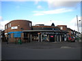
Bismillah Boutique, Ainsley Estate
Located on the corner of Northdown Road (left) and Grassington Road in Ainsley Estate, this distinctive building was presumably some sort of grocery shop before it became a boutique. According to Wikipedia, "Bismillah" is an Arabic phrase meaning "in the name of God", and is perhaps best known in the English speaking world for its presence in the song "Bohemian Rhapsody" by Queen.
Image: © Richard Vince
Taken: 1 Feb 2013
0.08 miles
9
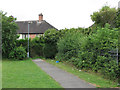
New Bridge to Northdown Road
This short twitchel links New Bridge and Northdown Road. Fifty years and more ago I hared along it most evenings, having skidded round the hairpin bend at the bottom of the lane from the bridge shown in Image] or lugged my bike down the steps (possibly a short cut, saving the second or two vital to twelve-year-olds), to watch the Waverley Express pass Robert Shaw Playing Field on the curve west of Radford Station.
Image: © John Sutton
Taken: 12 Jul 2011
0.09 miles
10
Southfield Road and the playing field entrance
Council-built houses on Southfield Road. The Ainsley Estate was planned before the Second World War but not completed until after it, as Nottingham continued to expand westwards. Image] shows the rear of these houses.
Image: © John Sutton
Taken: 27 Sep 2023
0.11 miles