IMAGES TAKEN NEAR TO
Harvest Crescent, NOTTINGHAM, NG8 2FA
Introduction
This page details the photographs taken nearby to Harvest Crescent, NG8 2FA by members of the Geograph project.
The Geograph project started in 2005 with the aim of publishing, organising and preserving representative images for every square kilometre of Great Britain, Ireland and the Isle of Man.

There are currently over 7.5m images from over14,400 individuals and you can help contribute to the project by visiting https://www.geograph.org.uk
Image Map
Images are licensed for reuse under creativecommons.org/licenses/by-sa/2.0
Notes
- Clicking on the map will re-center to the selected point.
- The higher the marker number, the further away the image location is from the centre of the postcode.
Image Listing (78 Images Found)
Images are licensed for reuse under creativecommons.org/licenses/by-sa/2.0
Image
Details
Distance
1
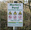
A walk round Martin's Pond (8)
Enjoy your visit? . . . If you dare!
This sign in the wooded north west corner of the nature reserve reminds visitors to respect both their own safety and that of the environment while still inviting them to enjoy themselves. Note how close the urban sprawl is, just visible through the trees.
See http://www.nottinghamcity.gov.uk/www/greenspaces/Docs/MartinsPondmap.pdf for a map of the site.
Previous image: Image, next image: Image
Image: © Kate Jewell
Taken: 11 Mar 2008
0.08 miles
3
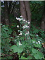
Canadian Fleabane
An attractive introduced member of the compositae, in scrub woodland surrounding Martins Pond.
Image: © Alan Murray-Rust
Taken: 19 Oct 2008
0.08 miles
4
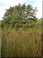
Martin's Pond
The north-west part of the pond is now choked with bull rushes.
Image: © Oxymoron
Taken: 10 Oct 2008
0.10 miles
5
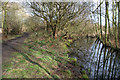
A walk round Martin's Pond (7)
As you progress along the northern edge of the pond the willow scrub becomes more mature and open, the roots holding the silt and leaf debris to form more solid ground, although it is still too soft to support visitors feet. Sensitive management of this area has provided a clear channel between the public access path and this marshy woodland to protect this vulnerable habitat.
See http://www.nottinghamcity.gov.uk/www/greenspaces/Docs/MartinsPondmap.pdf for a map of the site.
Previous image: Image, next image: Image
Image: © Kate Jewell
Taken: 11 Mar 2008
0.10 miles
6
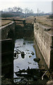
Nottingham Canal Wollaton Flight
About halfway down the flight of locks on the Nottingham Canal, looking towards the summit level, in 1963.The exact date of the shot is not known other than the year.
Image: © Richard Bird
Taken: 20 Apr 1963
0.10 miles
7
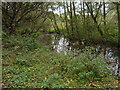
Martins Pond
This channel on the north side of the pond is being allowed to develop naturally into swamp/fen habitat rather than being dredged.
Image: © Alan Murray-Rust
Taken: 19 Oct 2008
0.10 miles
8
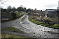
A walk round Martin's Pond (9)
To the west of the nature reserve is a large area of allotment gardens, all bounded by fences and hedges which are marked on the 1:25000 OS map. This view is looking west through the fence between the allotments and Martin's Pond nature reserve.
Previous image: Image, next image: Image
Image: © Kate Jewell
Taken: 11 Mar 2008
0.11 miles
9
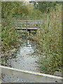
Boardwalk on Martins Pond
In the more enclosed part of the Pond precinct, the boardwalk allows close access to swamp-loving flora.
Image: © Alan Murray-Rust
Taken: 19 Oct 2008
0.12 miles
10
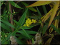
Goldenrod (Solidago gigantea)
Alongside the boardwalk on Martins Pond.
Image: © Alan Murray-Rust
Taken: 19 Oct 2008
0.12 miles