IMAGES TAKEN NEAR TO
Kennington Road, NOTTINGHAM, NG8 1QE
Introduction
This page details the photographs taken nearby to Kennington Road, NG8 1QE by members of the Geograph project.
The Geograph project started in 2005 with the aim of publishing, organising and preserving representative images for every square kilometre of Great Britain, Ireland and the Isle of Man.

There are currently over 7.5m images from over14,400 individuals and you can help contribute to the project by visiting https://www.geograph.org.uk
Image Map
Images are licensed for reuse under creativecommons.org/licenses/by-sa/2.0
Notes
- Clicking on the map will re-center to the selected point.
- The higher the marker number, the further away the image location is from the centre of the postcode.
Image Listing (96 Images Found)
Images are licensed for reuse under creativecommons.org/licenses/by-sa/2.0
Image
Details
Distance
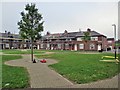
1
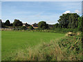
Robert Shaw Playing Field
Robert Shaw Playing Field - named for the nearby primary school - is the triangle of land between the Nottingham-Mansfield and Radford-Trowell railway lines at Radford Junction. Beyond the embankment of the Trowell line are some of the houses at the end of Kennington Road. The Radford author Alan Sillitoe describes children's fights on this bit of railway and the building of the council houses on either side of the line in the 1930s in his short story "The Decline and Fall of Frankie Buller". A more peaceful child, I cycled here most evenings fifty or so years ago to see the St Pancras to Edinburgh Waverley Express go by, coal trains on the Mansfield line and shunting on the Radford Colliery sidings away to the left.
Image: © John Sutton
Taken: 27 Aug 2010
0.06 miles
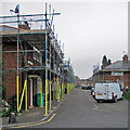
2
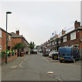
Re-roofing in Kennington Road
A drab and misty September morning in an area of Radford once known as Sodom, as older Nottinghamians may recall. Many of the Victorian terraces at the Wollaton Road end of this area were demolished in the 1970s, but the council houses built in the late 1930s remain.
Image: © John Sutton
Taken: 16 Sep 2014
0.06 miles
3
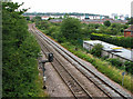
East from Western Boulevard Bridge
The green-and-white buildings in the distance are the Opal 1 student accommodation (Image]) built on land east of the former Radford Station once occupied by sidings, Chettle’s and Butterworth and Walker. This picture updates Stephen McKay’s Image], taken from the same place in 2008, before Opal 1 was built.
From the 19th century until the building of Western Boulevard and the council houses either side of it, a railway linking Babbington (Cinderhill) Colliery and the Nottingham Canal at a wharf immediately south of Wollaton Road crossed the Radford-Trowell main line at right angles and on the level here – where the tree on the right of the railway in the middle of this shot is; the colliery railway continued due south on a line corresponding to the boundary between the allotments and the back gardens of the houses on Newland Close (the first of which is on the right) and there were sidings and a weighbridge further south where Marchwood Close now stands. Until the abandonment of the colliery railway there was a signal box here, originally west of the colliery railway and later to the east. Babbington Sidings ran parallel to the main line back under the bridge and almost as far west as Woodyard Lane.
For other vestiges of the Babbington Colliery line, see Image], Image], Image] and Image
Image: © John Sutton
Taken: 12 Jul 2011
0.07 miles
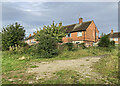
4
Newland Close, Western Boulevard
A burst of evening sunshine catches these local authority-built houses on a short cul-de-sac parallel with the Nottingham ring road.
Image: © Stephen McKay
Taken: 3 Jul 2008
0.09 miles
5
Re-roofing Chesil Cottages
This part of Radford originally developed near the railway station in the last quarter of the 19th century. It expanded in the 1930s when these council houses were built, and new houses like the one in the background on the right replaced some of the Victorian ones in the 1970s. When I was a boy this area was locally known as Sodom.
Image: © John Sutton
Taken: 16 Sep 2014
0.09 miles
6
New roofs in Chesil Street
A view from Canterbury Road, taken on a misty September morning. These council houses date from the 1930s, when the streets west of Radford Station were extended northwards. When I was a boy this part of Radford was known as Sodom.
Image: © John Sutton
Taken: 16 Sep 2014
0.11 miles
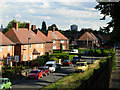
7
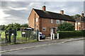
Houses backing on to Robert Shaw Playing Field
Council-built houses on Southfield Road. The Ainsley Estate was planned before the Second World War but not completed until after it, as Nottingham continued to expand westwards. Image] shows the fronts of these houses.
Image: © John Sutton
Taken: 27 Sep 2023
0.11 miles
8
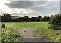
Robert Shaw Playing Field
In the early 1960s this was a good place to hang out with schoolfriends. A lot of trees have grown since then, obscuring the railway line to Mansfield and Worksop straight ahead and the line from Radford to Trowell Junction and the Erewash Valley Line to the right. Industrial units and student flats now occupy Radford sidings and goods yard on the other side of the Mansfield line, along which countless coal trains from the Leen Valley pits passed. The Waverley Express to and from Edinburgh via the Settle & Carlisle, which so excited small boys, no longer uses the route to Trowell.
Image: © John Sutton
Taken: 27 Sep 2023
0.11 miles
9
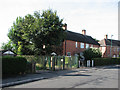
Southfield Road: Robert Shaw Playing Field entrance
This council estate was planned in the late 1930s, at the same time as Western Boulevard. My school friend Tim Dale lived in the house in the centre. We listened to a lot of early sixties music in the back bedroom "between the end of the Chatterley ban and the Beatles' first LP".
Image: © John Sutton
Taken: 27 Aug 2010
0.12 miles
10
Southfield Road and the playing field entrance
Council-built houses on Southfield Road. The Ainsley Estate was planned before the Second World War but not completed until after it, as Nottingham continued to expand westwards. Image] shows the rear of these houses.
Image: © John Sutton
Taken: 27 Sep 2023
0.12 miles