IMAGES TAKEN NEAR TO
St. Pauls Street, NOTTINGHAM, NG8 1PW
Introduction
This page details the photographs taken nearby to St. Pauls Street, NG8 1PW by members of the Geograph project.
The Geograph project started in 2005 with the aim of publishing, organising and preserving representative images for every square kilometre of Great Britain, Ireland and the Isle of Man.

There are currently over 7.5m images from over14,400 individuals and you can help contribute to the project by visiting https://www.geograph.org.uk
Image Map
Images are licensed for reuse under creativecommons.org/licenses/by-sa/2.0
Notes
- Clicking on the map will re-center to the selected point.
- The higher the marker number, the further away the image location is from the centre of the postcode.
Image Listing (136 Images Found)
Images are licensed for reuse under creativecommons.org/licenses/by-sa/2.0
Image
Details
Distance
1
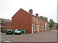
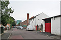
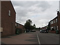
Radford: St Paul's Street
Many of the Victorian terraced houses at the Wollaton Road end of Kennington and Canterbury Roads were demolished in the 1970s, but this side of St Paul's Street remains. To the left, roofers are working on the council houses built in the late 1930s. This area, photographed on a grey September morning, was once known as Sodom, as older Nottinghamians may remember.
Image: © John Sutton
Taken: 16 Sep 2014
0.01 miles
2
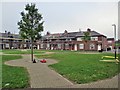
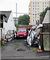
Re-roofing Chesil Cottages
This part of Radford originally developed near the railway station in the last quarter of the 19th century. It expanded in the 1930s when these council houses were built, and new houses like the one in the background on the right replaced some of the Victorian ones in the 1970s. When I was a boy this area was locally known as Sodom.
Image: © John Sutton
Taken: 16 Sep 2014
0.02 miles
3
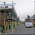
New roofs in Chesil Street
A view from Canterbury Road, taken on a misty September morning. These council houses date from the 1930s, when the streets west of Radford Station were extended northwards. When I was a boy this part of Radford was known as Sodom.
Image: © John Sutton
Taken: 16 Sep 2014
0.03 miles
4
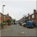
Re-roofing in Kennington Road
A drab and misty September morning in an area of Radford once known as Sodom, as older Nottinghamians may recall. Many of the Victorian terraces at the Wollaton Road end of this area were demolished in the 1970s, but the council houses built in the late 1930s remain.
Image: © John Sutton
Taken: 16 Sep 2014
0.05 miles
5
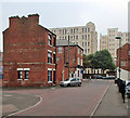
Radford: Medway Street
The white building in the centre is where Pearce's ice cream was once made. Older Nottinghamians will remember it clearly - bright white vanilla, with tiny shards of ice in it. The building is now occupied by another ice cream maker, Coronato Bros. The colourful building in the distance, on the other side of the railway, is Opal 1, a block of student flats.
Image: © John Sutton
Taken: 16 Sep 2014
0.06 miles
6
Medway Street: coal merchant's yard
Next to the former Pearce's ice cream factory (to the left). Player's Bonded Warehouse is in the background, on the corner of Wollaton Road and Triumph Road.
Image: © John Sutton
Taken: 16 Sep 2014
0.07 miles
7
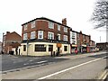
Fusion Bar and Restaurant, 36 Wollaton Road, Nottingham
On the corner of Kennington Road and Wollaton Road. Formerly the Midland Hotel.
Image: © Andrew Abbott
Taken: 31 Jan 2021
0.07 miles
8
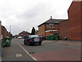
Kennington Road, Radford
Kennington Road is part of the catchment area for Southwold Primary School. It is a cul-de-sac, with a railway line running just beyond the furthest most houses.
Image: © Sally Holmes
Taken: 1 Aug 2006
0.08 miles
9
Dorset Street, Radford
Looking east along Dorset Street from Kennington Road to Canterbury Road.
Image: © Sally Holmes
Taken: 1 Aug 2006
0.08 miles
10
Radford: Kennington Road
Looking across the corner of Medway Street towards Wollaton Road and Player's Bonded Warehouse. Many of the Victorian terraces in this area - which, older Nottinghamians will remember, was once known as Sodom - were demolished in the 1970s. To the right, where the railings are, there was once a long terrace. The building on the left-hand corner of Wollaton Road, next to the 30mph sign, was once The Midland Hotel and the shop on the right was once a Shipstone's off-licence (or beer-off).
Image: © John Sutton
Taken: 16 Sep 2014
0.08 miles