IMAGES TAKEN NEAR TO
Gregory Boulevard, NOTTINGHAM, NG7 6LB
Introduction
This page details the photographs taken nearby to Gregory Boulevard, NG7 6LB by members of the Geograph project.
The Geograph project started in 2005 with the aim of publishing, organising and preserving representative images for every square kilometre of Great Britain, Ireland and the Isle of Man.

There are currently over 7.5m images from over14,400 individuals and you can help contribute to the project by visiting https://www.geograph.org.uk
Image Map
Images are licensed for reuse under creativecommons.org/licenses/by-sa/2.0
Notes
- Clicking on the map will re-center to the selected point.
- The higher the marker number, the further away the image location is from the centre of the postcode.
Image Listing (233 Images Found)
Images are licensed for reuse under creativecommons.org/licenses/by-sa/2.0
Image
Details
Distance
1
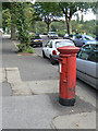
Post box NG7 74
EIIR 'Post Office' pillar box on Gregory Boulevard
Image: © Alan Murray-Rust
Taken: 27 Aug 2009
0.03 miles

3
Twentieth-century houses on First Avenue
These houses were built on what had been the large gardens of some of the substantial villas built c 1850-70, when First, Second and Third Avenues were established as some of the first part of the new suburb north of The Forest, part of the Borough's expansion after the Enclosure Act of 1845.
Image: © John Sutton
Taken: 5 Sep 2013
0.04 miles
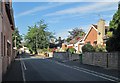
4
Nottingham - NG5 (Gregory Boulevard)
The Sherwood Rise end of Gregory Boulevard (A6130), a straight avenue of approximately one mile that was constructed and planted out in 1881. This road runs parallel with the edge of The Forest. Visible here are "The Stage Hotel" with Mansfield Road Baptist Church beyond it.
Image: © David Hallam-Jones
Taken: 5 May 2012
0.05 miles
5
Sherwood Rise: Second Avenue
The grand villas on First, Second and Third Avenues were some of the first houses built north of The Forest as Nottingham expanded after the Enclosure Act of 1845. Subsequently smaller houses have been built on some of the large gardens.
Image: © John Sutton
Taken: 5 Sep 2013
0.05 miles
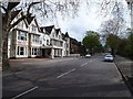
6
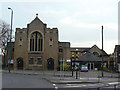
Mansfield Road Baptist Church
'The church on the corner'. It's not actually on Mansfield Road at all, but is sited on the corner of Sherwood Rise and Gregory Boulevard. Built in 1912.
Image: © Alan Murray-Rust
Taken: 15 Mar 2009
0.06 miles
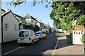
7
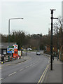
One of the few
The pole on the right is one of (literally) a handful of traction poles used to support the old tramway and later trolleybus overhead wires. This one survived because it had some other cable attached to it. This has now been cut away, but presumably it's not worth the cost of removing the pole. This was Nottingham's final trolleybus route.
Image: © Alan Murray-Rust
Taken: 15 Mar 2009
0.06 miles
8
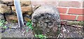
Lenton Parish boundary stone at junction of First Avenue and Sherwood Rise
The stone has the Milestone Society National ID: NT_NOT36pb and bears the inscription L P / 1855. Lenton was absorbed into Nottingham Parish in 1897 but there were earlier parish boundary changes in 1880.
Image: © Roger Templeman
Taken: 29 Jan 2022
0.06 miles
9
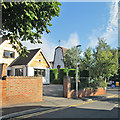
Sherwood Rise: two churches
The Polish church is on the left and the Victorian spire of St Andrew's, on Mansfield Road, is on the horizon.
Image: © John Sutton
Taken: 27 Apr 2011
0.06 miles
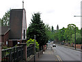
10
The corner of First Avenue and Sherwood Rise
First, Second and Third Avenues were some of the first suburban developments north of The Forest, with some substantial houses dating from c 1850-70, the period of the Borough's initial expansion after the Enclosure Act of 1845. The striking west front of the Polish Church of Our Lady of Czestochow is on the other side of Sherwood Rise.
Image: © John Sutton
Taken: 5 Sep 2013
0.06 miles