IMAGES TAKEN NEAR TO
Noel Street, NOTTINGHAM, NG7 6AU
Introduction
This page details the photographs taken nearby to Noel Street, NG7 6AU by members of the Geograph project.
The Geograph project started in 2005 with the aim of publishing, organising and preserving representative images for every square kilometre of Great Britain, Ireland and the Isle of Man.

There are currently over 7.5m images from over14,400 individuals and you can help contribute to the project by visiting https://www.geograph.org.uk
Image Map
Images are licensed for reuse under creativecommons.org/licenses/by-sa/2.0
Notes
- Clicking on the map will re-center to the selected point.
- The higher the marker number, the further away the image location is from the centre of the postcode.
Image Listing (229 Images Found)
Images are licensed for reuse under creativecommons.org/licenses/by-sa/2.0
Image
Details
Distance
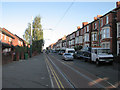
1
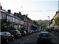
Noel Street - the newer side
Most of the houses on Noel Street date from the 1880s. The ones on the right replaced the short-lived deck-access flats which replaced the Victorian houses demolished in the sixties, which are shown in my north-pointing 1968 photo Image
Image: © John Sutton
Taken: 16 Apr 2010
0.02 miles
2
Burford Road
Looking south towards The Forest, over which an early-morning hot-air balloon is passing.
Image: © John Sutton
Taken: 24 Sep 2009
0.02 miles
3
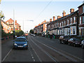
Noel Street
Tramlines just south of the junction with Berridge Road Central. Click http://www.geograph.org.uk/photo/1612734 to see the demolition, in 1967, of the houses which once stood on the left.
Image: © John Sutton
Taken: 24 Sep 2009
0.02 miles
4
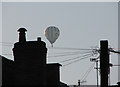
Balloon seen from Burford Road
I believe the balloon, in the livery of sponsors William Bailey Ltd of Ambergate, belongs to Nottingham Hot Air Balloon Club and was on a photographic mission early on a perfect late-September morning, when it made a fine sight for a man on a photographic mission in Forest Fields. I learn by Googling that the club may be unique in Britain in being the only non-profit sports balloon club open to the general public.
Image: © John Sutton
Taken: 24 Sep 2009
0.02 miles
5
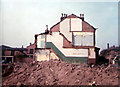
Demolition, Noel Street, 1967
The corner of Berridge Road, a little further up Noel Street, is on the right. See Image] for a 2009 view showing the houses which replaced the short-lived deck-access flats which replaced these late-Victorian houses.
Image: © John Sutton
Taken: 15 Apr 1967
0.03 miles
6
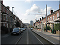
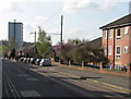
The Length of Noel Street - 2
This view south from Beaconsfield Street tram stop shows almost all of Noel Street, with Gregory Boulevard at the bottom of the hill and the climb past The Forest tram stop to Mount Hooton Road in the centre distance, to the left of Hyson Green's only high-rise block. The houses on Noel Street were built in the 1880s.
Image] is the northbound view, from the corner of Bentinck Road.
Image: © John Sutton
Taken: 16 Apr 2010
0.03 miles
7
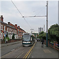
Hyson Green: a tram on Noel Street
A Hucknall-bound tram approaching Berridge Road on a drab September morning.
Image: © John Sutton
Taken: 12 Sep 2018
0.04 miles
8
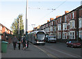
Tram on Noel Street
A Phoenix Park tram on the northbound single-track section.
Image: © John Sutton
Taken: 24 Sep 2009
0.04 miles
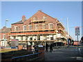
9
Noel Street
Looking north from the Noel Street tram stop.
Image: © John Sutton
Taken: 24 Sep 2009
0.06 miles
10
Noel Street: public house
It is now called the Frog and Onion, but when I walked or cycled past it every day on my way to school it was the Carlton Hotel. It was a Shipstone's tied house in those days, and the beer was delivered from just up the road by Shippo's famous red horse-drawn drays.
Image: © John Sutton
Taken: 24 Sep 2009
0.06 miles