IMAGES TAKEN NEAR TO
Tottle Gardens, NOTTINGHAM, NG7 5RZ
Introduction
This page details the photographs taken nearby to Tottle Gardens, NG7 5RZ by members of the Geograph project.
The Geograph project started in 2005 with the aim of publishing, organising and preserving representative images for every square kilometre of Great Britain, Ireland and the Isle of Man.

There are currently over 7.5m images from over14,400 individuals and you can help contribute to the project by visiting https://www.geograph.org.uk
Image Map
Images are licensed for reuse under creativecommons.org/licenses/by-sa/2.0
Notes
- Clicking on the map will re-center to the selected point.
- The higher the marker number, the further away the image location is from the centre of the postcode.
Image Listing (135 Images Found)
Images are licensed for reuse under creativecommons.org/licenses/by-sa/2.0
Image
Details
Distance
1
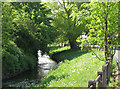
River Leen at Radford
Looking upstream.
Image: © Jonathan Thacker
Taken: 26 Feb 2024
0.03 miles
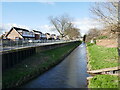
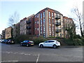
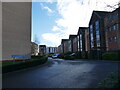
2
River Leen, Old Radford
The photograph is taken from the corner of Hartley Road and St Peters Street. Maun Avenue is on the left. This housing development was built on the site of Radford Folly, an 18th-century pleasure garden. The Folly itself - an octagonal tower - survived, in ruins, into the 1950s. For a description of the Radford Grove pleasure gardens, see the Nottinghamshire History website http://www.nottshistory.org.uk/whatnall1928/radford_folly.htm .
Image: © John Sutton
Taken: 20 Nov 2009
0.04 miles
3
Old Radford: swans and cygnets on the Leen
In my childhood after the war the much-straightened Leen was wider here, and much polluted by dyeing and bleaching works and other factories upstream. For a wider, non-zoom view from the same place in less leafy November 2009, see Image], which shows the houses built on brownfield sites either side of the river in the last part of the twentieth century.
Image: © John Sutton
Taken: 12 Jul 2011
0.04 miles
4
River Leen, Radford
The River Leen, whose name is believed to be a corruption of the Celtic word llyn (lake), flows southwards from its source in the Robin Hood Hills (near Kirkby in Ashfield) to the River Trent south of Lenton ('Leen-ton').
Image: © Stephen McKay
Taken: 3 Jul 2008
0.05 miles
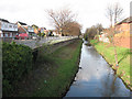
5
River Leen at Maun Avenue
It's hard to imagine that this tranquil spot was until the 1960s next to a colliery. Old photos of Radford Colliery show this concrete-post-and-iron-rail fence. Maun Avenue and the other streets of houses to the right were built in the 1970s on colliery and railway land. In the 18th century, though, this was Radford Grove http://www.nottshistory.org.uk/whatnall1928/radford_folly.htm , a fashionable pleasure garden, and Radford Folly, a stuccoed brick tower, survived in ruins into the 1950s, in a sea of colliery spoil.
Image: © John Sutton
Taken: 19 May 2010
0.05 miles
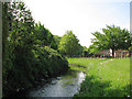
7
Part of the River Leen in Radford, Nottingham
Ducks sunning themselves here.
Image: © Jeremy Bolwell
Taken: 19 Jan 2020
0.06 miles
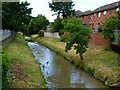
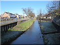
8
River Leen at Bobbers Mill
A friendly man walking his dog told me this area was "The Hidden Jewel of Bobbers Mill". It's hard to imagine that this tranquil spot was until the 1960s next to a busy colliery. Old photos of Radford Colliery show the concrete-post-and-iron-rail fence which now borders Maun Avenue. The streets of houses to the right were built in the 1970s on colliery and railway land. In the 18th century, though, this was Radford Grove http://www.nottshistory.org.uk/whatnall1928/radford_folly.htm , a fashionable pleasure garden, and Radford Folly, a stuccoed brick tower, survived in ruins into the 1950s, in a sea of colliery spoil.
Image: © John Sutton
Taken: 19 May 2010
0.06 miles
10
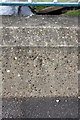
Benchmark on north parapet on New Road bridge over River Leen
Ordnance Survey rivet benchmark described on the Bench Mark Database at http://www.bench-marks.org.uk/bm47873
Image: © Roger Templeman
Taken: 31 Mar 2013
0.07 miles