IMAGES TAKEN NEAR TO
Chadwick Road, NOTTINGHAM, NG7 5NN
Introduction
This page details the photographs taken nearby to Chadwick Road, NG7 5NN by members of the Geograph project.
The Geograph project started in 2005 with the aim of publishing, organising and preserving representative images for every square kilometre of Great Britain, Ireland and the Isle of Man.

There are currently over 7.5m images from over14,400 individuals and you can help contribute to the project by visiting https://www.geograph.org.uk
Image Map
Images are licensed for reuse under creativecommons.org/licenses/by-sa/2.0
Notes
- Clicking on the map will re-center to the selected point.
- The higher the marker number, the further away the image location is from the centre of the postcode.
Image Listing (229 Images Found)
Images are licensed for reuse under creativecommons.org/licenses/by-sa/2.0
Image
Details
Distance
1
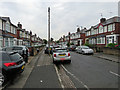
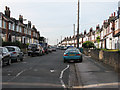
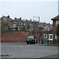
Bobbers Mill: Chadwick Road
These houses date from the late 1930s, when Nottingham expanded westwards beyond its Victorian edge. Mass car ownership was not envisaged then and these houses were built with without garages - hence the street parking and paved front gardens.
Image: © John Sutton
Taken: 12 Sep 2018
0.03 miles
2
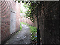
Plantation Side - 4
The narrowest part of the twitchel past Lindley & Lindley's factory.
Image: © John Sutton
Taken: 12 Aug 2009
0.03 miles
3
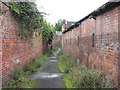
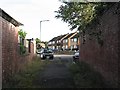
Plantation Side - 1
Partly footpath and partly suburban street, Plantation Side runs from Alfreton Road Bobbers Mill to Gauntley Street, near the former Gerard's Soap Works. This is the narrow footpath between parts of the Lindley & Lindley complex, looking towards Alfreton Road.
Image: © John Sutton
Taken: 12 Aug 2009
0.03 miles
4
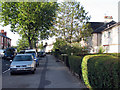
Bobbers Mill Road
Victorian red-brick terraced houses on the left-hand side and rendered inter-wars municipal housing on the right.
Image: © John Sutton
Taken: 24 Sep 2009
0.05 miles
5
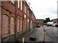
Lindley & Lindley
Part of the former hosiery works on Plantation Side.
Image: © John Sutton
Taken: 12 Aug 2009
0.05 miles
6
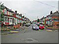
Chadwick Road
The north end, seen from near the junction with Darley Road.
Image: © John Sutton
Taken: 25 Sep 2009
0.06 miles
7
Bobbers Mill: along Chadwick Road
Looking from the Darley Road end towards Alfreton Road on a gloomy September morning. These houses were built in the late 1930s as Nottingham expanded westwards beyond its Victorian edge. The builders may not have envisaged the addition of a Doric colonnade to the front of the house on the left.
Image: © John Sutton
Taken: 12 Sep 2018
0.06 miles
8
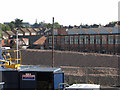
Piled bricks at Lindley & Lindley
Demolition of the former Lindley & Lindley factory site - latterly a business park - has been going on for some years and the large-windowed building with a sawtooth northlight roof is the only significant part remaining, the rest having been reduced to neat piles of broken brick. In this foreshortened zoom shot from Bobbers Mill Bridge the foreground is taken up with containers and lifts on the former woodyard; beyond Lindley & Lindley houses on Darley Road slope up to Bobbers Mill Road; behind them is St Stephen's Church, with its bellcote and spiky spire, and in the distance on the left Mount Street Mill on the top of the ridge which starts at Bobbers Mill and divides Radford, Hyson Green and Forest Fields from New Basford.
Image: © John Sutton
Taken: 15 Sep 2011
0.07 miles
9
Plantation Side
The Darley Road end of the twitchel which winds through the former Lindley & Lindley site. The houses ahead are on the middle part of Plantation Side, which is a road.
Image: © John Sutton
Taken: 13 Sep 2012
0.07 miles
10
An overcast morning on Plantation Side
The southern end of Plantation Side (straight ahead) is a narrow twitchel between high brick walls - and once, further on, the buildings of Lindley & Lindley's hosiery works. The backs of houses on Chadwick Road are on the skyline. Like those of Darley Avenue on the right, they were built in the 1930s.
Image: © John Sutton
Taken: 11 Apr 2013
0.07 miles