IMAGES TAKEN NEAR TO
Alfreton Road, NOTTINGHAM, NG7 5NL
Introduction
This page details the photographs taken nearby to Alfreton Road, NG7 5NL by members of the Geograph project.
The Geograph project started in 2005 with the aim of publishing, organising and preserving representative images for every square kilometre of Great Britain, Ireland and the Isle of Man.

There are currently over 7.5m images from over14,400 individuals and you can help contribute to the project by visiting https://www.geograph.org.uk
Image Map
Images are licensed for reuse under creativecommons.org/licenses/by-sa/2.0
Notes
- Clicking on the map will re-center to the selected point.
- The higher the marker number, the further away the image location is from the centre of the postcode.
Image Listing (205 Images Found)
Images are licensed for reuse under creativecommons.org/licenses/by-sa/2.0
Image
Details
Distance
1
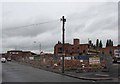
Bobbers Mill: demolition of the former Lindley & Lindley hosiery factory
This is at the corner of the old Alfreton Road and Plantation Side, looking towards the footbridge over the railway where there were once a level crossing and a signal box. This road became a side street when Bobbers Mill bridge was built in the 1930s to carry Alfreton Road over the Nottingham to Mansfield railway. Lindley & Lindley made nylon stockings. Latterly the buildings were leased to a number of businesses.
Image: © John Sutton
Taken: 12 Aug 2009
0.01 miles
2

Bobbers Mill: the Lindley & Lindley site
Not a lot has happened (but spot the differences) since I stood on more or less the same spot in April 2010 to snap Image There was rather more of the old factory waiting to be razed the previous August, as Image] shows.
Image: © John Sutton
Taken: 21 Jun 2011
0.02 miles
3
What remains of Lindley & Lindley
Not a lot has happened since I last passed this way in September 2011 - see Image], which has links to earlier pictures.
Image: © John Sutton
Taken: 11 May 2012
0.02 miles
4
Bobbers Mill: Alfreton Road old and new
The tarmac in the foreground is Alfreton Road, which becomes Bobbers Mill Bridge where the slope begins on the left of the picture. Bobbers Mill Bridge, built in the late 1930s at the same time as Western Boulevard as the city expanded westwards, replaced the old Alfreton Road, straight ahead, where there was once a level crossing over the Nottingham-Mansfield railway. The houses on the right are the same design as others in the area and also date from the late 1930s. The former Lindley & Lindley factory shown in Image] is behind them.
Image: © John Sutton
Taken: 15 Sep 2011
0.02 miles
5
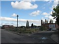
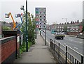
Bobbers Mill: the start of Plantation Side
Part twitchel, part suburban street and part footpath, Plantation Side leads from Alfreton Road at Bobbers Mill to Gauntley Street and Wilkinson Street, on the edge of New Basford. The building straight ahead is the only remaining part of the former Lindley & Lindley factory, now occupied by several businesses.
Image: © John Sutton
Taken: 15 Sep 2011
0.02 miles
6
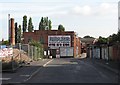
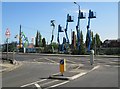
Bobbers Mill Bridge and Alfreton Road
Looking towards the city towards the end of the rush hour on a misty April Tuesday, with plenty of parking spaces in the city-centre multi-storeys. To the left is the parapet of the part of the bridge which crosses the River Leen. A City Transport Turquoise Line No 77 is making for Aspley Lane and Strelley.
Image: © John Sutton
Taken: 29 Apr 2014
0.03 miles
7
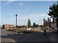
Across the road at Bobbers Mill Bridge
A view from the end of Poulter Close, towards the largely cleared site of the former Lindley & Lindley hosiery factory. When I lived nearby as a child, Radford Colliery was behind the camera, and what is now Poulter Close (but not the short new section of it nearest to Bobbers Mill Bridge) was its access road. This was a brighter morning than the one a month before when I snapped Image] on the old sawmill site in the wedge between the A610 and the old Alfreton Road.
Image: © John Sutton
Taken: 16 May 2013
0.03 miles
8
Bobbers Mill: the remains of Lindley & Lindley
Demolition of the former hosiery factory has been going on for some time. The broken bricks which are all that remain of the buildings which once filled the wedge between Alfreton Road (left) and Plantation Side have been piled more neatly since I was last here earlier in 2011 - see Image], which has links to earlier views.
Image: © John Sutton
Taken: 15 Sep 2011
0.04 miles
9
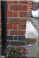
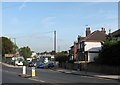
Benchmark on #545 Alfreton Road
Ordnance Survey cut mark benchmark described on the Bench Mark Database at http://www.bench-marks.org.uk/bm47877
Image: © Roger Templeman
Taken: 31 Mar 2013
0.04 miles
10
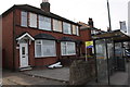
#545 Alfreton Road and Chadwick Road bus stop
There is an OS benchmark Image on the side of the house, right of the black downpipe.
Image: © Roger Templeman
Taken: 31 Mar 2013
0.04 miles