IMAGES TAKEN NEAR TO
Radford Boulevard, NOTTINGHAM, NG7 3BP
Introduction
This page details the photographs taken nearby to Radford Boulevard, NG7 3BP by members of the Geograph project.
The Geograph project started in 2005 with the aim of publishing, organising and preserving representative images for every square kilometre of Great Britain, Ireland and the Isle of Man.

There are currently over 7.5m images from over14,400 individuals and you can help contribute to the project by visiting https://www.geograph.org.uk
Image Map
Images are licensed for reuse under creativecommons.org/licenses/by-sa/2.0
Notes
- Clicking on the map will re-center to the selected point.
- The higher the marker number, the further away the image location is from the centre of the postcode.
Image Listing (150 Images Found)
Images are licensed for reuse under creativecommons.org/licenses/by-sa/2.0
Image
Details
Distance
1
Radford Methodist Church
The white panels are inscribed Methodist Sunday Schools 1890, so it is clear that the church has moved in at a later stage. It is now shared with commercial occupants.
Image: © Alan Murray-Rust
Taken: 7 Nov 2008
0.04 miles
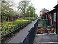
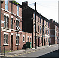
2
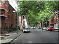
Radford Boulevard, Nottingham
in Victorian times a very fashionable area of Nottingham. Not so now, but still nice with all the trees.
Image: © Tom Courtney
Taken: 9 Sep 2005
0.04 miles
3
Forster Street: Radford Methodist Church
The church was designed by the Nottingham architect R C Sutton. A foundation stone beneath the blue notice board was "Laid on behalf of the sewing class by Mrs Smith". Another records the names of the Superintendent, Rev T Granger, the architect and the contractor, Mr W Savage. There has been only one slight external change since Alan Murray-Rust recorded the building on a brighter day in 2008: Image
Image: © John Sutton
Taken: 8 Jul 2015
0.04 miles
4
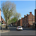
Along Radford Boulevard
A view from the junction with Ilkeston Road. Nottingham's boulevards were an enlightened piece of Victorian planning, creating a ring road from Carrington Street near the Midland Station to Mansfield Road at Carrington. (Be sure not to pronounce it boulvarr, in the French way - to true Nottinghamians it's a bulleevard.)
Image: © John Sutton
Taken: 5 May 2018
0.05 miles
5
Nottingham - NG7 (Radford)
Alvey Terrace is the name given to this row of bungalows hugging this private footpath and connecting two sections of Forster Street. The bungalows, the path and the maisonettes opposite them are owned by the Wm. Sutton Housing Trust. William Sutton (1833-1900) was a Londoner who made his fortune through door-to-door parcel deliveries (something the Royal Mail was not doing at the time) through his company, Sutton Carriers. After his death most of his wealth went into housing trusts named after him that still provide affordable housing for impoverished people. The former Radford Methodist church, now being used by another Christian church, can be seen in the distance.
Image: © David Hallam-Jones
Taken: 5 May 2012
0.06 miles
6
Leafy Radford
Radford Boulevard, near Denman Street corner, looking towards Alfreton Road and Gregory Boulevard. Castle, Lenton, Radford and Gregory Boulevards, laid out in the 1880s, were a piece of enlightened town planning, forming an early ring road, lined with genteel villas and some industrial premises, on the west side of the city.
Image: © John Sutton
Taken: 21 Jul 2012
0.06 miles
8
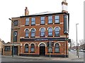
The Gregory, a pub converted to student flats
The Gregory was one of the core components of this junction: known as "'ation Corner" after the four buildings surrounding the junction: a church (SalvATION), a school (EducATION), a pub (DamNATION), and a pawnshop (RuinATION).
See http://nottstalgia.com/forums/index.php?showtopic=827 for more details.
Image: © SK53
Taken: 8 Apr 2013
0.07 miles
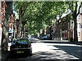
9
Denman Street Central
Until the clearance schemes of the late 1960s, Denman Street ran almost the whole length of Radford, from St Peter's Street in the west uphill almost to Canning Circus. It has now been truncated and partly pedestrianised. When I was growing up in these parts in the 1950s, Denman Street was quite a shopping centre. Three-storey houses and shops were a Nottingham speciality in the late Victorian period.
Image: © John Sutton
Taken: 21 Jul 2012
0.07 miles
10

The Gregory public house, Radford
On Ikeston Road.
Image: © JThomas
Taken: 9 Jul 2016
0.07 miles