IMAGES TAKEN NEAR TO
Country Crescent, NOTTINGHAM, NG6 8ZX
Introduction
This page details the photographs taken nearby to Country Crescent, NG6 8ZX by members of the Geograph project.
The Geograph project started in 2005 with the aim of publishing, organising and preserving representative images for every square kilometre of Great Britain, Ireland and the Isle of Man.

There are currently over 7.5m images from over14,400 individuals and you can help contribute to the project by visiting https://www.geograph.org.uk
Image Map
Images are licensed for reuse under creativecommons.org/licenses/by-sa/2.0
Notes
- Clicking on the map will re-center to the selected point.
- The higher the marker number, the further away the image location is from the centre of the postcode.
Image Listing (73 Images Found)
Images are licensed for reuse under creativecommons.org/licenses/by-sa/2.0
Image
Details
Distance
1
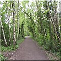
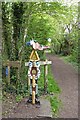
Leen Valley Walk, Bestwood, Notts.
The cycle track/footpath divides here with the right-hand path going towards Bestwood Country Park and the left-hand one heading towards Bestwood Road and Mill Lakes. I believe that this was previously the track bed of part of the former Great Northern Railway Leen Valley line.
Image: © David Hallam-Jones
Taken: 24 Jan 2014
0.04 miles
2
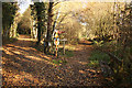
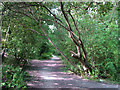
Broken birch
Forms a "arch" over NCN route 6 north of Bulwell.
Image: © David Lally
Taken: 27 Apr 2017
0.04 miles
3

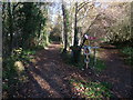
Leen Valley Walk, Bestwood, Notts.
Hucknall Road (the A611) is approximately 15-20 minutes walk ahead along this former track-bed. Bestwood Road (the B683) runs parallel, on the right, whereas farmland lines the left-hand side of the path behind the trees.
Image: © David Hallam-Jones
Taken: 24 Jan 2014
0.04 miles
6
Millennium milepost
On route 6 north of Bulwell.
Image: © David Lally
Taken: 27 Apr 2017
0.04 miles
7
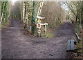
Route 6
Colourful waymark at a junction of paths - right to Bestwood Country Park, left to Mill Lakes on NCN route 6
Image: © Richard Croft
Taken: 25 Nov 2011
0.04 miles
8
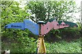
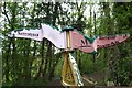
Cycle Route 6 milepost, Bestwood Country Park
Right to the park, left for Route 6 to Mill Lakes
Image: © Tim Heaton
Taken: 11 Nov 2012
0.04 miles
9
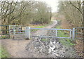
Bestwood Country Park, Notts.
An access point leading to the western side of Bestwood Country Park from a section of the Leen Valley Walk. This location is 5-10 minutes away from the eastern end of Mill Lane, to the left, and 10-15 minutes away from Hucknall Road (the A611) by continuing to the right.
Image: © David Hallam-Jones
Taken: 24 Jan 2014
0.05 miles
10
Former track of the Great Northern Leen Valley Line
The Great Northern Railway built this line to carry coal from the Leen Valley pits to its huge marshalling yards at Colwick, east of Nottingham. It opened in 1881, lost its passenger service in 1931 and closed completely in 1964. From Bulwell Forest to Bestwood it ran largely on a high embankment parallel to the road - now a traffic-free cycle route shaded by the trees and bushes which have grown tall since closure.
Image: © John Sutton
Taken: 13 Jul 2011
0.08 miles