IMAGES TAKEN NEAR TO
Park Road, NOTTINGHAM, NG6 8UE
Introduction
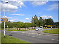
This page details the photographs taken nearby to Park Road, NG6 8UE by members of the Geograph project.
The Geograph project started in 2005 with the aim of publishing, organising and preserving representative images for every square kilometre of Great Britain, Ireland and the Isle of Man.

There are currently over 7.5m images from over14,400 individuals and you can help contribute to the project by visiting https://www.geograph.org.uk
Image Map (Loading...)


Getting Data...Please wait
Leaflet Map data © OpenStreetMap
Images are licensed for reuse under creativecommons.org/licenses/by-sa/2.0
Notes
- Clicking on the map will re-center to the selected point.
- The higher the marker number, the further away the image location is from the centre of the postcode.
Image Listing (94 Images Found)
Images are licensed for reuse under creativecommons.org/licenses/by-sa/2.0
Image
Details
Distance
1
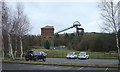
Car park entrance, Bestwood Country Park
This car park entrance provides access from Park Road, on the south eastern corner of Bestwood village, to a car park serving Bestwood Country Park. The entrance to Bestwood colliery was here: the colliery winding house, headgear and some other buildings have been preserved (see other pictures in this square), while some of the slagheaps have been landscaped and form part of the country park. The railway wheelsets behind the fence (centre) appear to be from an outside framed 350hp diesel shunter (BR class 08 or one of its LMS designed ancestors).
Image: © Richard Vince
Taken: 27 May 2013
0.03 miles
2
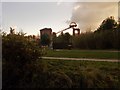
Bestwood Village
Sun setting behind the winding house
Image: © norman griffin
Taken: 26 Jan 2018
0.03 miles
3
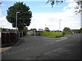
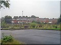
Bus turning circle, Park Road, Bestwood village
This turning circle would have been used by buses taking miners to and from the erstwhile colliery (out of frame to the right), which now forms part of Bestwood Country Park. Now, it merely enables buses to serve the south eastern part of the village by doing a double run along Park Road from Moor Road. The narrow lane off the turning circle (centre) provides access to a set of domestic garages. The green panel fence hides a new housing development, which the developers seem keen to avoid being associated with what should be a very convenient bus stop for its residents.
Image: © Richard Vince
Taken: 27 May 2013
0.04 miles
4
Bestwood Country Park - Car Park
This is the main access to the Country Park from the west and is overlooked by the old Bestwood Colliery winding engine house.
Image: © Alan Murray-Rust
Taken: 13 Jan 2008
0.05 miles
5
Bestwood Village
View north-west from the colliery car park. This is the modern end of the village, further west are some well-appointed Victorian miners terraces.
Image: © Trevor Rickard
Taken: 1 Aug 2009
0.06 miles
6
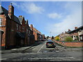
St, Albans Road, Bestwood Village
Nineteenth century colliery housing on the left,
Image: © Jonathan Thacker
Taken: 31 Mar 2022
0.06 miles
7
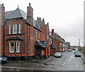
Bestwood Colliery Village: St Albans Road
The colliery company, which built these houses in the years after the sinking of the pit in 1872, was owned by the local landowner, the Duke of St Albans. These are rather grander houses than those on Park Road.
Image: © John Sutton
Taken: 7 Apr 2014
0.07 miles
8
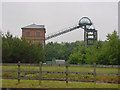
Bestwood Colliery
Headstocks and winding house at Bestwood. Closed 1967.
Image: © Q
Taken: 15 Jun 2005
0.08 miles
9
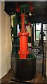
Bestwood Colliery - Brake Cylinder
A view of the brake engine (one of two), connected to large weights. The cylinder was semi submerged in water. There was also a hand brake.
Image: © Ashley Dace
Taken: 7 May 2011
0.08 miles
10
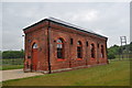
Bestwood Colliery - Dynamo House
A former dynamo house, now a small exhibition room as part of the museum site.
Image: © Ashley Dace
Taken: 7 May 2011
0.08 miles